Geoscience Reference
In-Depth Information
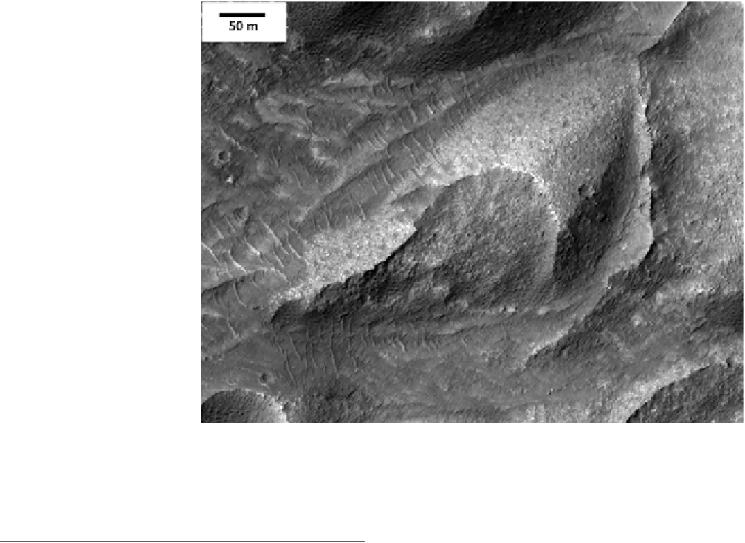
Fig. 12.27
A Martian dune
turned into stone. The
pockmarked and blocky surface
of this barchan dune indicates
significant cohesion and thus
evidence of induration. HiRISE
image ESP_025389. Credit
NASA/JPL/U.Arizona
not all dunes are immobilized. However, recent HiRISE
imaging has also revealed convincing evidence that some
Martian dunes are indurated (Fig.
12.27
).
CRISM spectrometer is likely to remain the state of the art
for hyperspectral remove sensing of Mars for the foresee-
able future, but perhaps someone will devise a very high
spatial resolution spectrometer that could focus on details
not resolvable today in CRISM data. An important addition
from an orbital perspective would be an imaging radar at
Mars, along the lines of the instrument that revealed [98 %
of the surface of Venus during the Magellan mission.
Correlation of radar return properties with existing imaging
and spectral data sets would open up a new realm of
understanding
12.9
Future Possibilities
Future missions to Mars represent new opportunities to
improve our understanding of aeolian sediments and land-
forms on Mars. The increasing scope and complexity of
missions correlates with their increased costs, which
(unfortunately) also then correlates with a decreasing
prospect for selection of large missions in an era of tightly
constrained budgets. We will point out some of the missions
that might advance the state of knowledge of Martian dunes,
from orbiters to specialized landers and rover and (even-
tually) to human exploration of Mars.
At present, the HiRISE camera continues to return a
steady stream of highly detailed images from all over Mars,
and it will likely remain the state of the art for orbital
imaging for the foreseeable future. Alternate derivatives
from the HiRISE design might sacrifice some of its mag-
nificent spatial resolution (and thus the required size of the
telescope) for improved spatial coverage and increased
spectral bands, which would allow for more precise map-
ping of compositional variations among moderate-scale
aeolian deposits than is available at present. Similarly, the
for
the
near-surface
materials,
including
evaluation of the depth of some deposits.
A new approach for investigations near the surface may
be either an airplane or balloon mission to Mars. Several
such concepts already have been proposed to NASA, and
technology may have advanced to the place where such
missions are now more feasible than they may have been in
the past. An airplane mission could allow for low-altitude
remote sensing along flight lines of perhaps thousands of
kilometers, while a balloon mission might cover a compa-
rable distance over a much longer time frame, and even
include multiple surface sampling opportunities as the
altitude of the balloon decreased during each night. Geo-
physical investigations in particular may be more amenable
to such low-altitude mission designs. Either mission type
would need to address science objectives that are difficult or
impossible to achieve using either orbiters or rovers.
Search WWH ::

Custom Search