Geoscience Reference
In-Depth Information
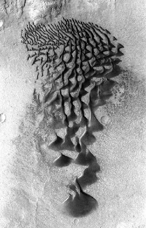
Fig. 12.14
Mariner 9 image (DAS 13315770) showing the north
polar cap with its spiral troughs and the deep gash Chasma Boreale.
Some outlying patches of frost are seen, as well as the irregular dark
ring around the 1000-km wide cap that make Mars' largest dune field,
the polar erg Olympia Undae. Credit NASA/LPI
12.5
Examples of Dune Localities on Mars
Multiple orbiting spacecraft missions have now documented
Mars at a variety of spatial scales, as discussed earlier.
However, the highest resolution datasets do not have global
coverage, since the data volumes would be prohibitive. The
Thermal Emission Imaging System (THEMIS) on the Mars
Odyssey spacecraft has provided a uniform image base with
global coverage and adequate resolution to evaluate dune
morphology. Thus the global inventory of dunes could be
systematically mapped (Fig.
12.9
), starting with the equa-
torial and mid-latitudes (65 S to 65 N; Hayward et al.
2007), followed by both the north (Hayward et al. 2010) and
south polar regions (Hayward et al. 2012). This mapping
effort identified dune fields down to a size of *1km
2
;
nearly 900 locations correspond to dune fields within
impact craters of various sizes, and the North Polar Erg
(NPE) is the only place where sand is abundant on a
regional scale. We can't hope to treat even most of these
widely dispersed sand deposits, but next we describe several
examples that can serve to illustrate both the similarities and
the differences of Martian dune fields as seen in both orbiter
and lander imaging (Fig.
12.14
).
North Polar Erg (72-82 N). A ring of sand called the
North Polar Erg (NPE) surrounds the north polar cap on
Mars, the one area on the planet that approaches the scale of
sand seas (ergs) on Earth. The International Astronomical
Union (IAU) has established guidelines for the nomencla-
ture of features identified on all mapped planetary surfaces.
Fig. 12.13
Interesting gradation between linear forms and 'teardrop'
barchans across the floor of Bunge Crater in response to winds blowing
from the direction at the top of the picture. The frame is about
14 kilometers wide. Mars Odyssey THEMIS. Image PIA13654
two Viking landers had suggested that at present the Mar-
tian winds only rarely exceed the threshold for initiation of
saltation, but the sub-meter spatial resolution of the HiRISE
camera has now documented that both sand ripples and sand
dunes have moved perceptibly during periods of from
movement has been detected at places widely spread across
the planet, and the inferred movement rates on Mars are not
unlike the rates of sand movement observed in some cold
and dry environments on Earth (Bridges et al. 2012b).
Below some of the sites of documented sand movement are
discussed in relation to their setting, but these are likely to
be only the first of a growing number of places where sand
is observed to be in motion on Mars under present condi-
tions, a situation that would have been very difficult to
imagine only ten years ago.


Search WWH ::

Custom Search