Geoscience Reference
In-Depth Information
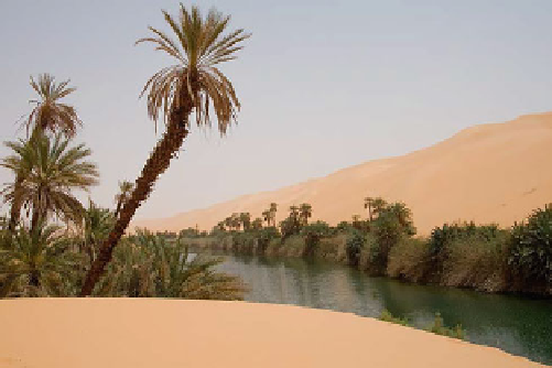
Fig. 11.5
Ubari oasis in the Erg Awbari, Libya, taken by Luca
Galuzzi, April 7, 2007 (Wikimedia Commons)
terrestrial example of what could be called a 'high desert'.
The high altitude of elevated deserts contributes signifi-
cantly to rather large temperature extremes throughout the
year, ranging from -40 C in winter to +50 C in the
summer. Recently, the steady rise in global temperatures are
causing the southern edge of the Gobi to expand into the
surrounding grasslands by about 3600 km
2
/ year. The
region referred to as the Gobi includes the Badain Jaran but
also several other dunefield areas.
The name 'Badain Jaran' is Mongolian for 'mysterious
lakes', illustrating how early inhabitants of this area in
northwestern China were surprised to find large lakes within
the vast sand mountains of this desert. More than 100
spring-fed lakes give the region its name (Fig.
11.8
—see
stabilize the horizontal movement of the adjacent sand
mountains (draa). This desert is best known for containing
the tallest stationary dunes on Earth, with individual sand
dunes attaining heights of up to 500 m.
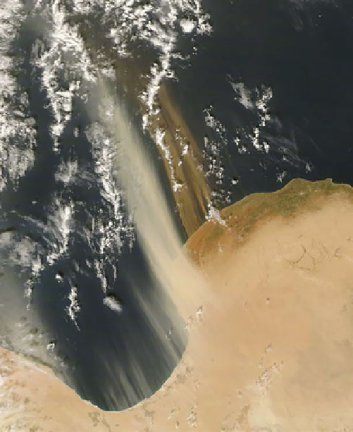
Fig. 11.4
The north coast of Libya, showing plumes of wind-blown
dust from the northern Sahara trailing into the Mediterranean. This
highlights not only the wind transport of solid material on Earth, but
also that the oceans act as at least temporary sinks for much sand and
dust which would otherwise accumulate. NASA MODIS image
11.3.3
Taklamakan
Known as either the Taklimakan or Teklimakan, the Tak-
lamakan desert is located within the Tarim Basin in
southwestern China, which is a tectonically depressed
region *1000 km 9 400 km (620 9 250 mi) in size.
Although it is a local depression, it is at high elevations
overall and can thus be cold in winter—in 2008 a weather
station in this desert measured a winter temperature of
-26.1 C(-15.0 F). Transverse dunes in the Taklamakan
have been studied by Wang (2002).
11.3.5
Namib
'Namib' means 'vast place' in the Nama language. This
coastal desert is located primarily in Namibia, on the
southwestern edge of Africa, but arid conditions extend into
adjacent countries as well. Coastal deserts like the Namib
(Fig.
11.9
) are the result of climatic conditions that cause
decreased rainfall along some stretches of different conti-
nental margins. The annual rainfall within the Namib is
actually very variable depending upon where you are
located within the desert, ranging from a low of only 2 mm
(0.08 in.) in the most arid portions of the desert to 200 mm
(8 in.) along the Great Escarpment, which forms the eastern
margin of the desert. Individual dunes in the Namib are up
11.3.4
Gobi/Badain Jaran
The name 'Gobi' is Mongolian for 'semidesert', which once
again is a very apt description for the abundant vegetation
that comprises what can be called Desert Steppe terrain.
Average annual rainfall throughout this desert region is
194 mm, which is more than twice the rainfall in even the
wettest portions of the Sahara. Located in western China,
the Gobi is Asia's largest desert, placed at an elevation that
ranges from 900 to 1500 m, making it also the largest

Search WWH ::

Custom Search