Geoscience Reference
In-Depth Information
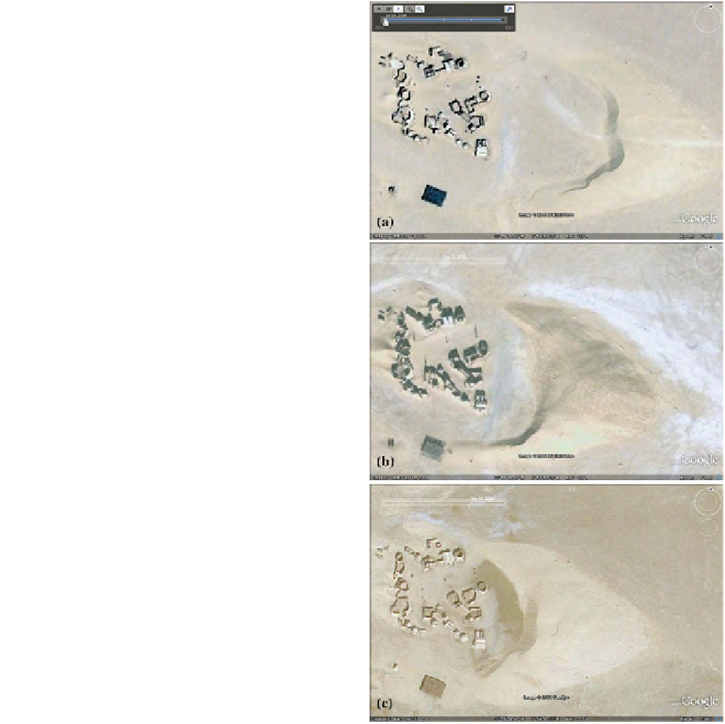
Fig. 9.4
A sequence of
commercial satellite images
(GeoEye) of the Star Wars film
set (see
Chap. 24
) in Tunisia,
visualized with the Google
Earth historical imaging too
(see Lorenz et al. 2013).
The movement of the dune, by
some 14 m/year, is evident
because the buildings serve as
fiducial reference markers. The
images were acquired on a 11
July 2004, b 21 January 2008 and
c 25 September 2009. Image
c was acquired the day before our
the dark band adjacent to the
circular building is seen to be a
temporarily wet area. Image
b was acquired with a lower sun
angle, and has more prominent
shadows. In this image vehicle
tracks are very evident on the
barchan. Images courtesy of Go-
ogle Earth
A third oft-cited barchan study, that of Long and Sharp
(1964) at the Salton Sea in California, USA, is notable in
that the studied dunes had somewhat diminished by the
mid-1990s, perhaps due to land-use change and consequent
effects on sand flux. Lastly, a relatively recent study by
Bristow and Lancaster (2004) documented the movement of
a small slipfaceless dome dune in the Namib between their
observation in 1999, and when Ed McKee had marked its
outline with stakes in 1976, 23 years earlier. The sand flux
associated with the 45 m-wide, 1 m-high dune moving
90 m in this period is only *2 % of the resultant potential
sand flow expected, indicating that such shallow dunes are
inefficient at trapping sand.
At the larger scale, walking the perimeter or the crest
of a dune with a GPS receiver (e.g., Fig.
9.5
; see also
Sect. 16.2.1
) is now an effective way of documenting the
outline of a dune. Conventional handheld receivers are
accurate to a meter or two, so displacements of the order
of 10 m can be easily documented; geophysical-grade
receivers with differential corrections are accurate to a few
centimeters. If satellite images can be adequately referenced
to GPS coordinates (e.g., by noting the position when
Search WWH ::

Custom Search