Geoscience Reference
In-Depth Information
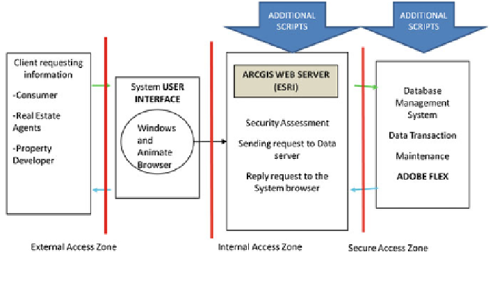
Fig. 4
The conceptual design of WGRPMIS
4. Select from the selected property polygon, with the query statement formed
using the user's input variables (Property Type and Price Range)
5. Create layer from the new selection
6. Calculate the route distance from the property to the user selected POI using
network analysis
7. If more than one property is found, iterate the process in no. 6
8. Display results.
The POI selection exhibited the highest requirement of potential property cri-
teria in which the system should allow interactive selection or query by attribute.
This is crucial as presented in the matrix of online marketing technological
dependencies (refer to Table
1
). In real estate business, POI is not only important
to market the property but an essential element to determine the property price.
This determinant has been recognised ages ago, indicating location and price has
been equally important in the property buying decision making (Chin and Foong
2006
; Kus an et al.
2010
). In summary, the property belonging services, facilities
and accessibility are the factors affecting house prices and further influenced by the
macro-economic variables, spatial differences, characteristics of community
structure, and environmental amenities (Kus an et al.
2010
; Kim and Park
2005
).
The improvements made to the design and the function scripts are illustrated in
Fig.
5
.
Figures
6
,
7
and
8
show the results of integrated geo-processing and geometry
network functions. The results indicate significant differences as compared to the
radius and buffer search functions in the pilot system.