Geoscience Reference
In-Depth Information
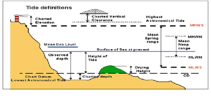
Fig. 1 Tide definitions that show the illustration of the terminology of tidal heights (Tide
Definitions
2011
)
characteristics without substantiating measurements. In order that they may be
recovered when needed such as datum are referenced to bench mark (FIG
2006
).
Lowest Astronomical Tide (LAT) is the lowest level of sea water where the sea
water never gets lower than this LAT value. LAT is determined by tide prediction
procedure using 18.6 years tide data. Chart datum has been rather more broadly
defined as the level below which no predicted tide shall fall by more than 0.1 m.
However, the Royal Malaysian Navy has chosen the lowest astronomical tide level
(LAT) as the chart datum in producing their tide table prediction and also pro-
duction of nautical charts in Malaysia. Figure
1
shows the tidal datum and its
relation to the coastline.
3 Tidal Datum Determination for Marine Cadastre
Commencement
Tides data from 12 Department of Survey and Mapping, Malaysia (DSMM) tide
gauge stations have been acquired to assist the determination of tidal datum as
shown in Fig.
2
. Tides data period was started from the year 1993 to 2012. The
computation of tidal datum is carried out using Total Tides Station (TOTIS) tidal
analysis software. The software is able to compute the tidal datum based on the
number of tidal constituents in relation to the number of months. The computation
of tidal datum will focus on the study area Langkawi. The type of tides in
Langkawi is semi-diurnal, consisting of two high tides and two low tides of nearly
equal level of the lunar day.
The computation of water level value is based on LAT. The number of con-
stituents will reflect the result. The analysis will cover the following periods:
15 days, 1 month, 3 months, 6 months, 1 year, every 5 years and 18.6 years.
Table
2
tabulates the tide analysis period for 2012.