Geoscience Reference
In-Depth Information
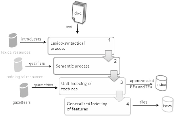
corresponds to a regular or administrative (city, county, etc.) splitting of the area
covered by the document repository followed by a projection of the spatial features
(SFs) of the unitary index in this grid. Following the same principle, temporal
standardization corresponds, for example, to a calendar grid on which the temporal
features (TFs) of the unitary index are represented.
Figure 3.2. A fourth stage in the PIV indexing flow
This additional indexing stage presents a twofold interest. It allows us to bring the
various spatial and temporal representations to a homogeneous representation
supported by uniform spatial and temporal tile-based segmentations. Moreover, it
allows the implementation of state-of-the-art models for computing IR relevance
scores based on such spatial and temporal tiles given their frequency in documents.
Such a generalization (i.e. standardization) leading to gathering geographic features
into tiles causes some loss of accuracy [CHR 90]. This is balanced, however, by the
introduction of tile frequency computation, as well as the computation of indexes of
different scales (i.e. ranges). Thus, for example, the city zoning index (respectively
county index) will be used if the query targets a city (respectively a larger area).
3.4.1.1. Standardization by tiling: example
Let us take the example of a text containing the sentence “I passed near Bayonne
in early January 2001”. The PIV process flows will analyze this text and create a
first level of indexes associating a geometry with the SF “near Bayonne” (see SF
#5
,

Search WWH ::

Custom Search