Geoscience Reference
In-Depth Information
as “12 July” and thematic such as “granite” (to be considered, for example, from
a mineral point of view) or “firs” (of particular interest from a botanical point of
view).Letusalsonotethevaryinglevelsofthecomplexityofinformation: wereferto
“Argelès”asasimplespatialinformationwhereas“outskirtsofArgelès”isacomplex
spatial piece of information that evokes a relation of adjacency whose interpretation
necessitates an additional analysis of the text.
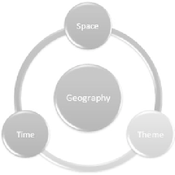
- Geographic information: Thecentralelementofthecorpusbeingthegeographic
information, let us review a definition coming from geomatics: illustrated in
Figure1.2,itconsidersgeographicinformationtobeasamoleculenotonlycomposed
of a spatial component, but also of a temporal component and a thematic component,
or phenomenon [USE 96, GAI 01]. For example, the text “musical instruments in the
vicinityofLarunsatthebeginningofthe19
th
Century”fullydescribesthisgeographic
molecule, with “musical instruments” corresponding to the thematic component. Let
us note that some components might nonetheless be absent.
In the geography markup language (GML) specification
10
and the research on
databases [LE 04], we can see the appearance of the notion of temporality. Thus,
it is possible to associate a piece of geographic information with one or more
geo-referenced representations, valid at a certain moment in history [GAL 01]. For
instance, a city or a forest has a variable spatial definition over time which can be a
creation,adisappearance,anexpansionorareduction.Finally,aphenomenonisoften
associated with it: subject of research, for example, a regional pollution at a given
period of time [PAL 10a].
Figure 1.2. Spatial, temporal and thematic dimensions
of geographic information
10 http://www.opengeospatial.org/standards/gml.

Search WWH ::

Custom Search