Geoscience Reference
In-Depth Information
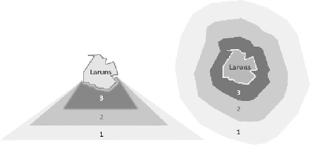
Figure 4.6. Interpretation of orientation and adjacency with
different levels of uncertainty
Anexperiment[SAL 08] hasallowedustoshowanimprovementinthequality of
GIR results linked to the calculation of more accurate geometries for the
representation of the spatial relations of adjacency and inclusion. These new
algorithms target the improvement of the precision of numeric representations of
RSFs and reduce the problem of noise linked to the approximations by bounding
boxes. It would be interesting to continue exploring this path, integrating the notion
of “vagueness”.
4.2.2. Interdimensional axis
We have developed a GIR system combining spatial, temporal and thematic IRSs.
The scores of the documents returned by this GIRS mainly depend on those obtained
foreachofthedimensionsinvolvedinthequery.Wenowproposethedevelopmentofa
targetedsemanticanalysisoftheretrieveddocuments.Onceadocumentispronounced
relevant, n pieces of information (spatial, temporal and/or thematic features) of the
document match all or a part of the search criteria expressedin the query.Wepropose
analyzing the relations between these relevant features in the document. This will
be followed by a new weighing of this document. This weighing will be based on
reinforcing or opposing aspects of those relevantfeatures. The list of proposed results
isthusre-ranked.ThefirststageoftheGIRproceedsasalargesievetoproposeafirst
list of documents. The second, more accurate stage of analysis, because it targets the
studyofrelationsbetweenfeaturespronouncedrelevant,wouldallowustoreviewthe
result list.
Figure4.7illustratesthreetypesofresultsobtainedforthesamequery.According
tothecase,ananalysisofthepartsthathaveallowedustoqualifythedocumentinthe
result list can allow us to recalculate the relevance level of the document.
Search WWH ::

Custom Search