Geoscience Reference
In-Depth Information
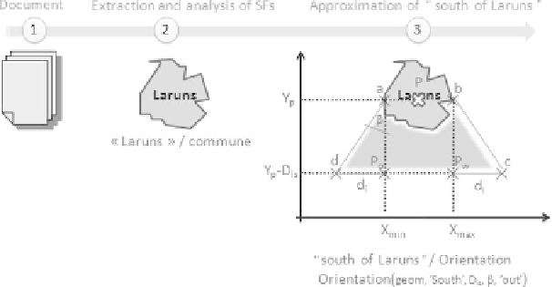
According to principles similar to the processing of adjacency, we propose
improving the interpretation of the orientation relation currently supported by
bounding box-type representations. Figure 4.5 illustrates a representation of the
orientation function. This functions contains five parameters: the geometry geom of
the reference SF, the direction D
ir
(here south) indicated, the distance D
is
corresponding to the scope of the orientation relation, the angle β of construction of
the form of the representation and the context of implication of the reference SF (in,
out or inOut).
Scharl and Tochtermann [SCH 07] qualify spatial relations of “vague”, due to the
difficulty of modeling subjective natural knowledge. Thus, the fuzzy notion seems
equally interesting to us in the context of the approximation of relative spatial
features (RSFs) by numeric representations. We propose dividing a representation
into geographic zones associated with levels of reliability as illustrated in Figure 4.6.
The most relevant zone has a level of reliability of n (3, for example, in Figure 4.6)
and the least relevant zone corresponds to a level that tends toward 0 (1, for example,
in Figure 4.6). This approach allows us to integrate a level of uncertainty in the
indexing phase. In the IR phase, the spatial areas represented as such will be
compared to those of the query by the matching function; the reliability ratings will
have an impact on the calculated relevance score. So, this fuzzy notion, transcribed in
the geometries relative to the indexed features, will allow us to extend a query with a
small number of results or restrict a large set of results to the most relevant
ones.
Figure 4.5. Interpretation of orientation: orientation function
Search WWH ::

Custom Search