Geoscience Reference
In-Depth Information
This is a way of filtering the set of documents resulting from the query presented
in Figure 4.1 or even of completing it with new documents. This approach consists of
using the relations described in an ontology in order to build the query result.
To our knowledge, only the CITER GIRS [PFO 09] uses themes coming from an
ontology: itisonlyinthephaseofIRthattheuserselectsathemeintheproposedlist
for the search.
4.2.1.2. Spatial dimension
We are interested in the interpretation of spatial information detected in texts. Our
objective is to make more accurate the approximation of the SFs indexed by the PIV
process flow.
The current version of the PIV system proposes specific functions of calculating
spatial relation representations [LES 07, SAL 08]. These functions are mainly based
on propositions contributing to the interpretation of relations of adjacency and
inclusion made by Malandain [MAL 00].
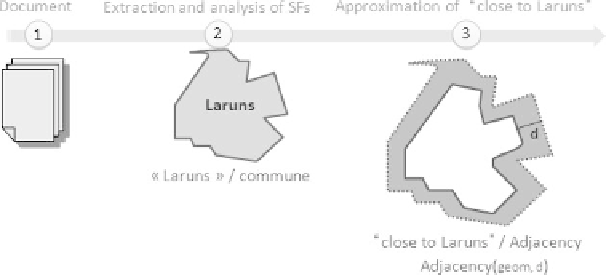
Figure 4.2 illustrates the adjacency function supporting the calculation of a
polygon from an initial geometry. This function contains two parameters: the
geometry geom of the reference SF and the distance d corresponding to the scope
associated with this adjacency relation. It proposes a numeric interpretation of
information expressed by phrases such as “next to, close to, around, in the periphery
of, in the proximity of, in the surroundings of, nearby, encircling”.
Figure 4.2. Interpretation of adjacency: basic adjacency function
It is possible to go further in the definition of such functions. For example, the
adjacency function can be improved and so extended to the use of four parameters,
Search WWH ::

Custom Search