Geoscience Reference
In-Depth Information
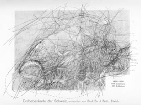
fig. 4.1. Earthquake map of Switzerland, based on the first thirty years of the
Earthquake Commission's activities, during which it collected seven thousand
felt reports. Johannes früh, “ueber die 30-jährige Tätigkeit der Schweizerischen
Erdbebenkommission,” in
94. Jahresversammlung der Schweizerischen Naturforschenden
Gesellschaft,
vol. 1,
Vorträge und Sitzungsprotokolle
(1911).
Geologists today view earthquakes on Swiss territory as the continuing
effect of the collision between the European and African plates that began
the formation of the Alps approximately 80-90 million years ago. Strong
earthquakes occur infrequently, but small tremors are common and often
accompanied by distinctive sounds. In the Alps, earthquakes can trigger
rock slides or avalanches or make rivers impassable. Today earthquakes are
estimated to represent one-third of Switzerland's total disaster risk.
5
According to the calculations of the Swiss Earthquake Commission, be-
tween 1880 and 1904 there was an average of six to seven “Swiss” earth-
quakes per year—meaning seismic events separated in time, observed by
at least two people, and with epicenters inside the Swiss borders.
6
(See fig-
ure 4.1.) Before the commission began its work, earthquakes in Switzerland
were often not recognized as such. Many residents mistook them for strong
winds or thunder. It was not uncommon for people to accuse their upstairs
neighbors of making noise that was actually seismic in origin. In some cases
witnesses were aware only that the horse pulling their carriage had stopped
dead in its tracks.
7
Some residents attributed the vibrations to an “invasion
of a legion of cats, mice, or rats in the garrets.”
8
These tremors rarely caused
much damage: “In general buildings have very infrequently been damaged,
thanks to their solid construction, in particular of the wooden buildings of
the mountain region. In many cases cracks in walls and in the ground, ava-