Geoscience Reference
In-Depth Information
GS
meanders
sl
cool
Mid-
Atlantic
Bight
water
MAB
sl
sl
MAB
tongue
transports
N and E
warm
Gulf
Stream
sl
breach
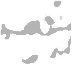
Fig. 6.26
The Gulf Stream is usually a continuous, though complex, meandering filament of warm Caribbean water in transit to the shores of
northwestern Europe. In these satellite images an unusually strong north wind has driven cool waters from the Mid Atlantic Bight across the
track of the Gulf Stream, breaching it as a cool tongue that is eventually itself transported north and east in the main current. Main northern
margin to Gulf Stream is a boundary shear layer (sl).
the northern hemisphere and anticlockwise (to the left) in
the southern hemisphere.
Let us apply these simple notions of conservation of
angular momentum to real-world oceanic gyres by a
vorticity balance
, taking into account the action of wind
shear, the change of
f
with latitude, and the effects of
boundary layer friction at the ocean edges. The simplest
physical model for a symmetrical wind-driven gyre would
be in 2D and have westerlies and trades blowing opposite
in a clockwise circulation, both declining to zero at the
horse latitudes (Fig. 6.28). One can see immediately that
the wind velocity gradients will cause a clockwise angular
velocity of rotation (i.e. addition of negative vorticity to
the water) and that the magnitude of the pressure gradi-
ents due to Ekman transport will determine the strength
of the resulting water flow. We must also take into account
the linear rate of change of the planetary vorticity,
f
, with
latitude, as this also determines the transport vector.
Finally, since we are concerned with solving the problem
of western intensification against the solid boundary of the
continental rise, we recognize that the sense of boundary
layer friction will cause the addition of positive vorticity on
both western and eastern boundaries. The combined effect
of wind and
f
on the western side enhances the negative
vorticity. On eastern margins the two effects roughly cancel
out. For the western current to remain steady and in bal-
ance the frictional addition of positive vorticity must be
made more intense. This can only be done by increasing
the current velocity, since the braking action provided by
boundary layer friction is proportional to velocity squared.
The warm western currents are thus extremely strong, up
to ten times the strength of the cool eastern currents.
It should not be thought that strong western boundary
currents have no effect at oceanic depths. Direct current
80
°
w
70
°
w
60
°
w
45
°
N
45
°
N
0
39
°
N
39
°
N
0
0
0
33
°
N
33
°
N
0
0
27
°
N
27
°
N
80
°
w
70
°
w
60
°
w
0
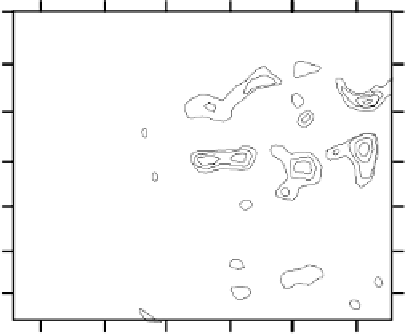
-50 cm -10
sea surface height
(1 m of topography over a typical eddy length of
c
. 250 km
gives a mean slope of 1: 250,000: note the asymetric slopes caused by
radial flow around the meandering Stream)
Fig. 6.27
Map of northwest Atlantic sea surface topography as meas-
ured by remote sensing from altimetric satellite Jason-1. The map
shows strong topographic features (mesoscale eddies) associated
with meanders of the surface Gulf Stream current. Geostrophic the-
ory (Fig. 6.5) says that flow should parallel the topography, defining
in this case the sinuous flow around a compex series of warm and
cold core eddies.
-30 cm
+10
+30
+50 cm
absolute vorticity constant it must therefore lose relative
vorticity. As the
major
part of the flow away from the ocean
bottom boundary layer is deemed frictionless the external
flow lags rotation of Earth and therefore loses positive rela-
tive vorticity, that is, gains negative relative vorticity. In
other words the flow rotates clockwise (i.e. to the right) in


Search WWH ::

Custom Search