Geoscience Reference
In-Depth Information
(b)
(a)
50º
40º
San
Andreas
fault
USA
30º
(c)
Legend
Normal faults
Strike-slip fault
Core complexes
Motion direction
during extension
Mx
20º
500 km
120º 110º 100º
(d)
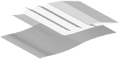
Fig. 5.44
Extensional tectonics of the western United States. (a) Map shows huge extent of the Basin and Range province with its arrays of
normal faults and the location of the chief core complexes. Star indicates the site of the 1985 Borah Peak normal faulting earthquake. Large
shaded arrows indicate the direction of extention revealed by the normal faults bounding the core complexes. (b) Field photo of part of the
impressive surface fault break of the Borah Peak earthquake. Mike is standing on the uplifted footwall block, facing the subsided hangingwall
block; total displacement is some 3.0 m. (c) and (d) show sequential development of a core complex due to a period of rapid, high exten-
sional strain causing unroofing and uplift of mid-lower crust along a major low-angle crustal detachment normal fault system (to right of
pointer).


Search WWH ::

Custom Search