Geoscience Reference
In-Depth Information
vertical gnomon, observed at noon and by measuring the
height of Polaris above the horizon. This star is vertically
above the North Pole and at 0
at the equator. Later they
mapped stars close to the South Pole for the same purpose
in the southern hemisphere. They were also able to use Polaris
to correct for secular magnetic variations in the magnetic
compasses that they invented. Portuguese mariners first
determined latitude from Euclidean geometry by the angu-
lar height of the midday Sun above the horizon adjusted for
time of year. Gilbert (
c
.0.4 ka) discovered geomagnetism
and the latitudinal dependence of the magnetic inclination
(Fig. 1.14). He measured magnetic latitude,
, by
observing the inclination,
I
, of compass needles and making
an approximation to the relation we now calculate as
tan
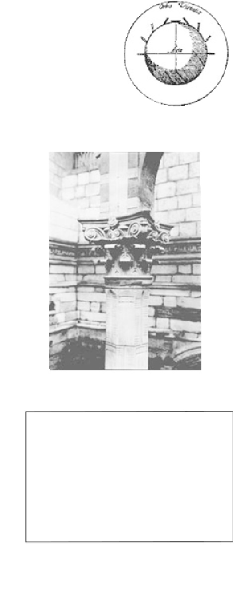
Fig. 1.14
William Gilbert's epoch-making topic preface with his
sketch of magnetic inclination variation around Earth's surface.
0.5 tan
I
.
1.4.6
Longitude
Accurately knowing time from shadow lengths, Chinese
astronomers and navigators (
c
.0.58 ka) computed longi-
tude accurately from determining the onset of lunar
eclipses at different locations and made corrections for
orbital eccentricity and obliquity of the ecliptic. In the
Western maritime tradition, longitude on the ocean was
computed with the aid of the accurate clock invented by
Harrison (
c
.0.22 ka). This was set for reference to
Greenwich time at zero longitude; local time at the lati-
tude in question then being estimated by sighting the
Sun's zenith (maximum angular distance above the hori-
zon), corresponding to local noon.
1.4.7
Eccentric rotation of the orbital axis
Fig. 1.15
The Umayyad period Nilometer on Roda Island designed
and built by the Turkestani astronomer Alfraganus.
Hipparchus of Rhodes (
c
.2.12 ka) compared the position
of Polaris with that of Thuban in Draco, used as pole star
by Egyptian/Babylonian astronomers. The effect gives the
22 ky precession of equinoxes cycle.
1.4.8
Earth fluxes
As the earliest example, the Egyptians set up “Nilometers”
to measure Nile water levels (Fig. 1.15). These were like
modern flood gauges and measured height in cubits above
low water. The annual record of the Ethiopian-sourced
flood peaks were carefully preserved, for comparative
purposes doubtless, although the time series were lost.
Fortunately, later Nilometers and their records built by
Arab and other dynasties (Fig. 1.16) have survived (they
were used for tax purposes: the higher the flood, the more
1,400
1,200
1,000
800
Year
BP
Fig. 1.16
World's oldest time series from the Roda Nilometer. Such
records provide important evidence to evaluate paleoclimate proxies
over medium-term time scales.


Search WWH ::

Custom Search