Geoscience Reference
In-Depth Information
(a)
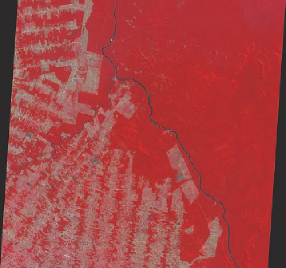
(b)
Figure 2.25 Infrared satellite images.
(a) This image of the region around Baltimore, Maryland, shows areas of vegetation in bright red
and urban areas as bluish gray. Areas of dark shading consist of water, specifically part of Chesapeake Bay. (b) Deforestation in the Amazon
rainforest as seen from NASA′s Terra Satellite. Dark red represents uncut forest, whereas the lighter shades of red indicate the pattern of
forest clearing. The dark wavy line in the image is the Jiparaná River. Note how the image path appears to be tilted slightly. This shape
reflects the slight inclination of the satellite′s Sun-synchronous orbit.
then measure the time it takes for the pulse to return, plus
its strength, to create a picture of the landscape. Such im-
agery can be obtained either from an airplane (Figure 2.26)
Although much can be learned by viewing Earth as hu-
mans normally see it, a great deal more information can be
acquired by investigating the landscape in the invisible parts
of the spectrum. This analysis often occurs by examining the
thermal infrared energy emitted by Earth. All objects emit this
kind of energy, but the relative amount varies depending on the
temperature—warm objects emit more energy than cold ones—
and the overall emissivity of the object. With a thorough under-
standing of these properties, geographers can see very subtle
differences on the landscape and thus determine the spatial
distribution of specific features such as vegetation, rock, and
water. Areas such as these can be studied frequently in this fash-
ion with infrared aerial photography, while larger regions can
be investigated on an annual basis with Sun-synchronous satel-
lites. Figure 2.25 shows a pair of infrared satellite images. This
kind of analysis is especially useful, for example, as a means of
showing urban patterns (Figure 2.25a) and monitoring defores-
tation in tropical rainforests (Figure 2.25b).
The methods described so far are passive systems in that
they depend on energy emitted by objects on Earth to obtain
measurements. Another form of remote sensing relies on ac-
tive systems that send a beam of wave energy toward Earth.
This beam is then partially reflected back to the sensor, which
can make measurements about the amount of energy emitted.
A good example of this kind of system is
radar
, which uses
energy in the microwave part of the electromagnetic spectrum.
Radar systems emit short pulses of energy toward Earth and
Figure 2.26 Acquisition of Synthetic Aperture Radar (SAR)
imagery from an airplane.
In this system, a radar unit at the
base of the airplane sends radar waves to the ground in a sweep-
ing motion across the landscape. Subsequently, these waves
bounce back to the airplane where their timing (from and to the
airplane) and strength are calculated and converted into an image
of the landscape.