Geoscience Reference
In-Depth Information
D I S C O V E R . . .
THE MARS ROVER
(a)
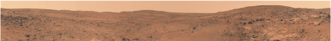
Panoramic image of the Martian landscape taken by
Spirit Rover
in 2005.
This image was taken with a camera on board the rover and
then sent back to Earth via radio waves where it was subsequently processed into this digital file. Given that the distance between Earth
and Mars varies between about 78 million km (48 million mi) to 377 million km (230 million mi), it takes between 4 minutes and 20 minutes
for the data to reach Earth.
Digital technology allows scientists to examine many aspects
of Earth, including soils, the hydrosphere, biosphere, and ter-
rain. One of the most fascinating ways that digital technology
is being employed to understand planetary history is on Mars.
Mars has always been a source of great interest to scientists
because it formed at about the same time as Earth, is similar
in size (certainly compared to the giant planets such as Saturn
and Jupiter), and is in the same part of the solar system. Most
importantly, strong evidence exists that liquid water once
flowed on Mars and may even remain there hidden below the
surface. If so, it is possible that primitive life once existed on
Mars and may still do so in some remote and simplistic way.
In this scientific context, the National Aeronautic and
Space Administration (NASA) is currently in the midst of
a rigorous program to explore Mars. The most interesting
aspect of this program is the deployment of rovers on the
surface to investigate the environment and geology. These
rovers arrived after a nine-month trip from Earth and have
been subsequently directed from scientists on Earth. A pair
of rovers,
Spirit
and
Opportunity
, landed on the surface in
early 2004 and began exploring the planet, sending digital
imagery and data back to scientists on Earth. Although
Spirit
became stuck in sand after six years,
Opportunity
continues
to roam the surface with direction from scientists at NASA.
A new rover,
Curiosity
, landed in Gale Crater on Mars
in August 2012.
Curiosity
is a much more sophisticated
(b)
Artist's conception of the
Curiosity Rover
vaporizing a rock on
the Martian surface.
The rover is about the size of a car and has
the ability to drill into rock, excavate shallow trenches, and conduct
experiments to search for organic material and various chemicals.
machine than the earlier rovers, having the ability to drill into
rock, excavate trenches, collect samples, and conduct com-
plex chemical experiments. This rover's goals are to inves-
tigate the Martian climate, geology, and the role of water in
shaping the landscape and providing a suitable environment
for microbial life. An early finding was that flowing water
once existed in the crater.
Curiosity
should run for several
years and promises to generate some amazing data that
could very well change our view of life in the universe. Pay
attention!
the change as it was occurring. The fact is that major changes can
occur on a landscape in a very short period of time and geogra-
phers usually want to see them quickly.
With the development of satellite technology in the 1950s
and 1960s, our ability to remotely sense the landscape increased
dramatically. As you know, satellites are mechanical platforms