Geoscience Reference
In-Depth Information
Map ScaleT
T A B L E 2 . 2
Large-Scale Maps
Small-Scale Maps
Used for maps of small geographic areas.
Used for maps of large geographic areas.
Used to illustrate great detail, such as road networks and
locations of parks.
Used to illustrate limited geographic detail, but show spatial
relationships of large areas.
Representative fraction is a large number, such as 1:1000.
Representative fraction is a small number, such as 1:25,000.
Isolines
Isolines,
another important map component, are lines that
connect points of equal value. These lines are particularly
useful, for example, when showing regional temperature and
precipitation patterns, elevation, or atmospheric pressure.
These data can be derived in a variety of ways and then used to
illustrate fundamental geographic trends. For example, imagine
that you want to create a map showing the pattern of high
temperatures throughout the United States on any given day.
The first thing you would do would be to access the temperature
measurements taken at all of the National Weather Service
sites in the country and show them on a map. This map would
contain an outline of the country, state boundaries, the various
locations where temperature measurements were taken, and the
temperature at each place (Figure 2.19a).
Although this map would contain the information you
desire, it would be difficult to discern any geographic pattern
because the map contains nothing but a series of numbers. By
looking at the numbers closely, you could perhaps determine
Lines on a map that connect data points of equal value.
Isolines
8
8
9
9
11
11
9
9
11
11
12
12
11
11
12
12
13
13
13
13
13
13
14
14
15
15
13
13
14
14
15
15
15
15
15
15
(a)
(b)
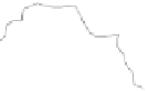
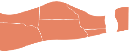
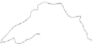
Figure 2.19 Drawing
isolines.
(a) Spatial dis-
tribution of data points,
in this case temperature
in degrees centigrade.
(b) Interpolating the 14º
isotherm. A line is drawn
connecting points where
14º measurements were
obtained. The position
of the 14º isoline is es-
timated between loca-
tions where 13º and 15º
temperatures were mea-
sured. (c) Isolines drawn
at intervals of 2°C. (d)
The resulting map shows
the spatial distribution of
temperature in the upper
Midwest.
8
8
9
10
11
9
11
12
11
12
13
12
13
13
14
15
13
14
15
15
15
14
(c)
(d)