Geoscience Reference
In-Depth Information
Figure 19.3 Eustatic sea-level changes
during the late Quaternary Period at New
Guinea.
Dramatic low sea levels occurred
during the Illinoisan glaciation (called the
Riss glaciation
in Europe) and Last Glacial
Maximum, with increases following these
glaciations. Sea-level rise the past 10,000
years is often called the
Holocene Trans-
gression
. (
Source
: Reprinted by permission
from Macmillan Publishers Ltd: J. Chappell
and N. J. Shackelton, 1986, “Oxygen Iso-
topes and Sea Level,”
Nature
324: 137-140.)
Present interglacial
0
Present sea level
Holocene transgression
50
Illinoisan/Riss
glaciation
Last glacial
maximum
100
150
0
20
40
60
80
100
120
140
Age (thousands of years ago)
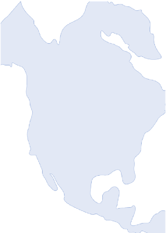
One of the important outcomes of the Pleistocene eustatic
changes was that the amount of continental land subaerially
exposed—that is, above water—varied a great deal over time. This
variation can be seen in Figure 19.4, which shows the configuration
of the North American coastline today, at peak glacial time, and at a
peak interglacial if all global ice sheets melted. As you can see, the
amount of land above sea level during the peak glacial period was
significantly greater than it is today.
Referring back to Figure 19.3, note that water levels dur-
ing the most recent glacial periods were about 125 m (410 ft)
lower than they are today. At these times, large parts of the
now-submerged continental shelf were subaerially exposed (see
Figure 19.4 again) and rivers extended onto that platform. The
evidence for these rivers can be seen in the form of canyons
cut into the shelf deposits during the major low ocean levels.
An excellent example of such a canyon is the Hudson Canyon,
which was eroded into the continental shelf by the ancestral
Hudson River. Similar features also exist on the floor of Chesa-
peake Bay (Figure 19.5a), which is essentially a large river val-
ley, or
ria
, that was flooded when the sea level rose during the
Holocene. Rias are common along many coastlines, with some
of the most beautiful found in New Zealand (Figure 19.5b). The
glacial counterpart of a ria is a
fjord
, which is an ice-formed
(u-shaped) trough that becomes flooded when sea level rises.
Excellent examples of fjords exist in places such as Alaska,
Norway, and the south island of New Zealand.
Tides
Tides are regular and predictable oscillations that oc-
cur with respect to the level of the world's oceans (Figure 19.6).
These oscillations are related to Newton's law of gravitation,
which states that every particle in the universe attracts every
other particle. According to this law, both the Moon and Sun
exert a gravitational force on the Earth. Although it would seem
that the Sun has the biggest influence on tides due to its immense
size, the Moon's gravitational effect is actually greater. This is
because the strength of the force is inversely proportional to the
distance: the closer the two bodies, the stronger the pull. Recall
from Chapter 3 that the average distance from Earth to the Sun
Land Area
Peak glacial
Modern period
Peak interglacial
Figure 19.4 Configuration of the North American coast-
line during peak glacial, peak interglacial, and modern pe-
riods.
Over time sea level has fluctuated greatly due to the
amount of water tied up in ice sheets. Note the configuration of
the coastline if all ice sheets melted.
Ria
A former river valley along the coast that is flooded by
rising sea level.
Fjord
A former glaciated valley along the coast that is flooded
by rising sea level.