Geoscience Reference
In-Depth Information
Mauritania
Mali
Senegal
Niger
Sudan
Chad
Sahel Region
Eritrea
Nigeria
Gambia
Ethiopia
Burkina Faso
(b)
Figure 18.28 The Sahel region in Africa.
(a) This region
is an ecotone that lies between the grass and forested
regions to the south and the Sahara Desert to the north.
(b) The Sahel landscape. Note the widely-spaced trees and
intervening grass that makes good pasture during the wet
season. It can easily be overgrazed, however, leading to
landscape disturbance.
(a)
that is, the number of people living there did not exceed what
the landscape could support without degradation. This sensitive
relationship began to change in the late 1800s when European
nations (primarily Great Britain and France) parceled the region
into distinct colonial entities. With this organization, artificial
boundaries arose that became barriers to the annual cycle of
nomadic migration. In addition, the economic focus changed
from living within the regional carrying capacity to exploiting
raw materials for consumption in Europe. Although the colonial
era ended in the mid-20th century with the advent of African
nationalism, the political boundaries, and their effect on hu-
man behavior, remained in place. People became increasingly
sedentary, which resulted in the cultivation of fragile soils,
overgrazing, and the removal of trees for firewood. In addition,
overall population increased because people from more humid
regions in the south migrated to the Sahel in search of places to
cultivate.
As a result of the combined factors of boundary establish-
ment and increasing population, the Sahel landscape began to
degrade in the early 20th century because the carrying capacity
was greatly exceeded. Landscape degradation and desertifica-
tion of the Sahel reached a catastrophic level during the late
1960s and early 1970s. As you can see in Figure 18.29, this
period coincides with a major period of drought that has basi-
cally lasted to the present time. Coupled with the preexisting
human-induced degradation that had already occurred on the
landscape, this drought resulted in widespread desertification
in the region.
2
1
0
-1
-2
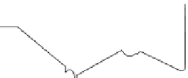
1890 1900 1910 1920 1930 1940 1950 1960 1970 1980 1990 2000
Year
Figure 18.29 Annual rainfall from June through October in the Sahel, 1898-2010.
In this graph, 0 represents the mean amount of
rainfall during this period. Positive numbers above the mean are annual amounts of rainfall that are above the mean. Conversely, negative
values below the mean represent below-average amounts of precipitation. Until the late 1960s, the region was relatively wet. Drought condi-
tions have dominated since that time. (
Source
: NOAA.)