Geoscience Reference
In-Depth Information
Eolian Processes and Landforms
Now that we have discussed the basic components of eolian pro-
cesses and associated landforms, let's visualize these concepts
in an animated format. To do so, go to the
Geo Media Library
and open
Eolian Processes and Landforms
. This animation de-
scribes the fluid flow of air and how it shapes the landscape. In
this animation, you will see how abrasion shapes rock outcrops;
how the variables of sand supply, wind direction, and vegetation
influence the formation of dunes; and how loess develops. After
you complete the animation, be sure to answer the questions at
the end to test your understanding of this concept.
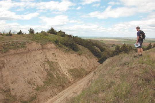
Earth because loess is calcareous and has high water-retention
capacity. Second, loess maintains nearly vertical faces upon
exposure (Figure 18.26). This durability occurs because the
silt grains are strongly attracted to one another and are bound
together by the calcium carbonate contained within it.
2.
The wind is an efficient sorting mechanism, which
means that sediments are separated by size. Clay-sized
particles travel the farthest from the source area. Silts
move an intermediate distance, and pebbles and grav-
els remain in place because they are too large to move
by wind.
3.
Another eolian deposit is loess, which is windblown silt
that is carried great distances in suspension before it
settles to the ground. Loess covers much of the Earth
and is very fertile.
KEY CONCEPTS TO REMEMBER ABOUT
EOLIAN LANDFORMS
1.
The best-developed depositional eolian landforms are
sand dunes. Sand dunes occur in a variety of forms, de-
termined by wind direction and strength, sand supply,
and the amount of stabilizing vegetation.
Human Interactions
with Arid Landscapes
and Eolian Processes
In Chapter 16 we examined how humans interact with stream
systems, such as in urban environments or by building dams.
Humans can also impact the eolian landscape in many ways. In
several examples around the world, people have contributed to
the degradation of a landscape through the process of
deserti-
ication
, that is, transforming a formerly vegetated landscape
into one that is relatively barren and highly susceptible to wind
erosion. This process is enhanced in marginal, semi-arid land-
scapes where the vegetation density is already low. Figure 18.27
shows extensive regions of Earth that are susceptible to deserti-
fication. Until recent times, people have generally avoided these
kinds of landscapes because rainfall to sustain crops and ani-
mal herds is unpredictable. However, with increasing popula-
tion pressure, more and more people have been moving into
these formerly uninhabited places in search of land that can be
cleared for farmland. In the process of this development, the
impact on the landscape has been enormous. As you will see
in the following discussion, human-induced desertification can
have catastrophic consequences.
Figure 18.26 Loess landscape in south central Nebraska.
This roadcut exposes a thick sequence of loess that largely
accumulated during the Wisconsin glaciation when the climate
in the region was drier and strong winds blew. The dark band
in the exposure is a buried soil that formed at the end of the ice
age when the landscape stabilized. Above the soil is loess that
accumulated during the early Holocene when the climate was
warmer and drier. The Platte River valley lies in the background.
The hills between the exposure and river valley are also underlain
by loess.
Desertification
The process through which a formerly veg-
etated landscape gradually becomes desert-like.