Geoscience Reference
In-Depth Information
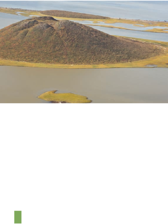
figure 17.36 a pingo.
A pingo, such as this one in the North-
west Territories in Canada, forms when water is injected into the
ground under some form of hydraulic pressure. This pressure
forces the ground to bulge upward.
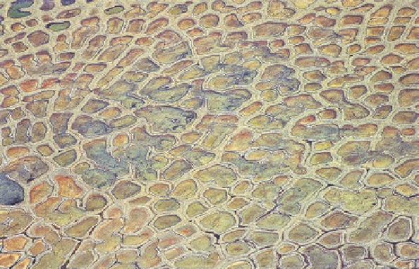
figure 17.37 patterned ground.
The distinctive polygons on
this landscape form when frost action preferentially brings large
stones and rocks to the surface.
when additional water is added. Finally,
intrusive ice
is ground
ice that forms when water is injected under pressure, perhaps be-
cause it lies between a pair of aquicludes. Where intrusive ice is
found, the surface of the ground can bulge up to 60 m (200 ft)
upward, forming a landform called a
pingo
(Figure 17.36).
In addition to pingos, frost action can result in a variety of
other landforms. A
palsa
(Spanish for “elliptical”) is a rounded
or elliptical mound of peat that is similar to a pingo in that it
is thrust upward. It differs from a pingo, however, because it
is only 1 m to 10 m (3 ft to 30 ft) high and contains ice lenses
rather than a solid core. Another distinctive periglacial landform
is
patterned ground
. As the name implies, patterned ground is
a landscape that has evolved such that it contains distinctive
shapes. These shapes are usually polygons (Figure 17.37) that
form when frost action preferentially brings coarser materials—
stones and boulders—to the surface.
S u m m a r y o f K e y C o n C e p t S
1.
Glaciers form when snow accumulates annually and
does not melt during the summer months. In this way,
the snow mass gradually thickens with each pass-
ing year and gradually changes into glacial ice through
compression.
5.
Glaciers deposit sediment either directly as till or
indirectly from meltwater streams as outwash. These
processes produce landforms such as moraines, kames,
and outwash plains.
6.
During the Pleistocene Epoch (between about 1.6 million
and 10,000 years ago), glacial ice covered up to 30%
of the Earth's land surface including extensive parts of
North America, Europe, and Asia. The most recent pe-
riod of massive glacial advance within the Pleistocene
was the Wisconsin glaciation, which ended approxi-
mately 10,000 years ago. Glaciers now cover about 11%
of Earth's landmasses. These tremendous fluctuations in
ice volume are intimately related to gradual changes that
occur with respect to Earth-Sun geometry.
2.
A growing ice mass becomes a glacier when it begins to
flow under its own weight. Whether a glacier advances
or retreats depends on the glacial mass budget, which is
the balance between snow accumulation in the source
area and melting at the zone of ablation. Melting and ac-
cumulation are in balance along an equilibrium line.
3.
Ice fields and ice caps are large ice masses that spread
horizontally across mountainous landscapes. Valley
glaciers flow down preexisting stream valleys in alpine
settings. Continental glaciers, such as the Antarctic Ice
Sheet, are thousands of meters thick and spread across
continental landmasses.
7.
Evidence for the Pleistocene ice ages is found in many
places in the northern part of the United States and
Canada. The Great Lakes, for example, were created be-
cause large ice lobes enlarged preexisting stream valleys.
4.
Glaciers erode the ground beneath them through the
combined processes of abrasion and plucking. In alpine
settings, these processes change the landscape from
generally rounded to much more angular, with sharp fea-
tures such as arêtes, horns, and cirques.
8.
Permafrost refers to ground that is perpetually frozen,
forming features such as ice wedges and pingos. Areas
of current permafrost conditions occur at high latitudes
and altitudes.