Geoscience Reference
In-Depth Information
notice that the edges of the flattened hemisphere are severely
distorted; in this case, they are split. In fact, the only way to
make the hemisphere become perfectly flat is to either stretch
or cut the edges.
Maps contain the same kind of distortion because spatial
information from the curved surface of Earth is essentially
spread over a flat surface. Because of this distortion, a vari-
ety of map projections have been developed, with each kind
presenting location and distortion in a different way that can
preserve either shape or size, but not both. Geographers are
keenly aware of the strengths and weaknesses of each kind of
projection with respect to spatial analysis and select the type
of map they want to use accordingly. Although it is not neces-
sary at this introductory level for you to understand maps as
thoroughly as a geographer does, you must know something
of the properties that result from the various projections that
are used to create them. Such a fundamental understanding
can be obtained by examining two simple kinds of projec-
tions: conformal and equivalent.
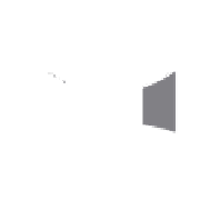
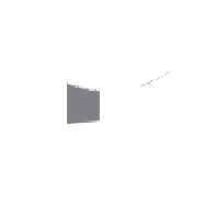
Figure 2.13 Why map distortion occurs.
On the left is the
semicircular (undistorted) half of a lime. Once the center of the
lime is pressed to the table to make it flat, distortion occurs at
the edges. Note that the area covered by the flattened part of the
lime is larger than that beneath the uncut part of the lime.
Conformal (or True Shape)
A
conformal projection
is
a map that maintains the correct shape of features on Earth
but distorts their size relative to one another. A conformal
projection is conceptually constructed by placing a translucent
cylinder over the globe and shining a light centered within the
globe outward so that an image is transferred to the cylinder
(Figure 2.14). If the cylinder is then removed from the globe
and cut so that it can be laid flat, a map will result.
Although projection serves the purpose of creating a flat
map that is potentially more usable than a globe, a problem re-
sults because it is not possible to flatten a sphere (such as Earth)
without some distortion of the image. Look at what happens in
Figure 2.13 if a lime is sliced in two so that two hemispheres
are created. If either of the two hemispheres is flattened on a
table, it covers a larger area than it did when it was intact. Also
Greatest
distortion
Light source
at center
of globe
Least
distortion
Greatest
distortion
Projection of globe
onto flat wall
Cylindrical surface
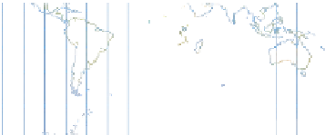
Figure 2.14 A conformal projection.
Imagine a cylindrical surface surrounding the globe with a source of light
at the center of the globe. The surface is unwound to produce a flat map. The regions of greatest distortion occur
at the top and bottom of the map.
Conformal projection
A map that maintains the correct
shape of features on the Earth but distorts their relative size to
one another.