Geoscience Reference
In-Depth Information
Although the evidence is extremely vague, the first ma-
jor glacial period on Earth appears to have occurred during
Precambrian time about 2.3 billion years ago. This glaciation was
in response to a major fluctuation in the composition of the early
atmosphere. Prior to this period, the atmosphere was composed
mostly of methane, an important greenhouse gas. Sometime ap-
proximately 2.3 billion years ago the amount of oxygen in the at-
mosphere increased dramatically, which in turn cooled the planet
so that much of it was covered by ice. Ice was so extensive at
this time that the period is sometimes called the
snowball Earth
.
During this glacial interval, many of the world's oceans were
frozen to a depth of about 0.8 km (0.5 mi). Similar “snowball”
glacials occurred later in Precambrian time, about 750 million
and 600 million years ago, and are most closely associated with
decreases in carbon dioxide, another greenhouse gas.
Although much of Earth was heavily glaciated during these
so-called snowball glaciations, the most recent and best-under-
stood glacial periods are those associated with the Pleistocene
Epoch between about 1.6 million to 10,000 years ago. During
this epoch of time, alpine and continental glaciation occurred
on such a large scale that 30% of the Earth's landmasses were
covered by glacial ice at its maximum extent. For perspective,
remember that contemporary glaciers now extend over only
11% of the Earth's land surface.
Until the latter part of the 20th century, glacial geomor-
phologists believed that four major advances of glacier ice
occurred during the Pleistocene Epoch. This history was sug-
gested through the reconstruction and dating of stratified tills in
Europe and North America. In North America, these “classic”
advances were named after the locations in which the ice
advanced to its farthest point and strong evidence was found in
the form of distinctive glacial drift. These glacial periods were
given the following names (and approximate ages):
1.
Nebraskan—1 million years ago
2.
Kansan—600,000 years ago
3.
Illinoisan—300,000 years ago
4.
Wisconsin—35,000 to 10,000 years ago
In each of these advances, a thick continental glacier ex-
tended from the Arctic to a point deep within the American
Midwest. East of the Rocky Mountains, this glacier is typically
referred to as the
Laurentide Ice Sheet
because it covered the
Laurentian Mountains in eastern Canada. Thick ice caps also
covered much of the Rockies and extended west to the Pacific
coast and south into Washington. Collectively, these ice caps are
referred to as the
Cordilleran Ice Sheet
, which, at its maximum
extent, merged with the Laurentide Ice Sheet in central Canada
to form a single ice mass across much of North America. Ac-
cording to classical theory, the Laurentide Ice Sheet reached
its southernmost point during the so-called
Kansan glaciation
about 600,000 years ago (Figure 17.28). This is the glacial
advance that stopped at present-day northeastern Kansas and
deposited the glacial erratic shown in Figure 17.14.
West Longitude
East Longitude
150
°
120
°
150
°
90
°
60
°
30
°
0
°
30
°
60
°
90
°
120
°
60
°
N
60
°
N
30
°
N
30
°
N
Pacific Ocean
ic
Equator
a
0
°
0
°
Pacific Ocean
c
Indian
Ocean
30
°
S
30
°
S
Atlantic Ocean
a
e
3000 km
0
0
0
3000 mi
m
60
°
S
60
°
S
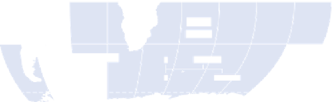
Ice sheet or glacier
Figure 17.28 Maximum extent of glaciation during the Pleistocene Epoch.
During this period of time, glaciers cov-
ered 30% of the Earth's land surface, compared to 11% today.
Laurentide Ice Sheet
The continental glacier that covered
eastern Canada and parts of the northeastern United States
during the Pleistocene Epoch.
Cordilleran Ice Sheet
The ice cap that covered much of the
mountains in the northwestern part of North America during
the Pleistocene Epoch.