Geoscience Reference
In-Depth Information
Projection of
globe onto
flat wall
(a)
Cross section
of light beam
Light source at
center of globe
(b)
Figure 2.12 The projection theory.
Light from a source proj-
ects the information on the curved surface of the Earth onto a
plane, forming a flat map.
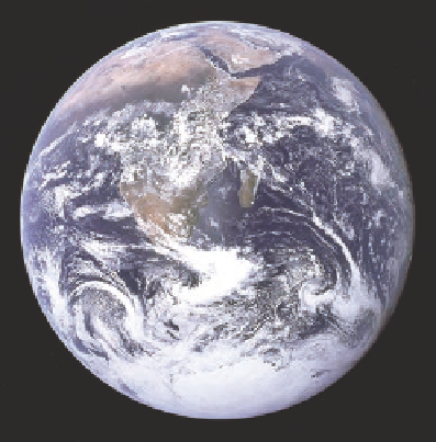
Figure 2.11 The globe and planet Earth.
(a) A globe portrays
geographic information about Earth in a three-dimensional fash-
ion. (b) Compare the image of the globe with this picture of Earth
taken from space. This particular Earth view focuses on Africa.
task can be accomplished in a variety of ways. The most visu-
ally accurate and complete way to illustrate the entire Earth is
through the use of a globe (Figure 2.11), which depicts locations
on the three-dimensional representation of the planet. Globes
can be cumbersome to use, however, and often do not illustrate
the level of detail desired. Instead, geographers frequently rely
on two-dimensional maps to show various geographic locations
and attributes. Many factors must be taken into consideration to
represent these features most accurately.
A simple way to visualize how projection works is to imag-
ine a light source passing through a curved translucent surface
that has an image on it, projecting the image from the curved
surface onto a flat wall (Figure 2.12). Light from the source
(the light bulb) streams out toward the wall in straight lines.
Before it reaches the wall, however, the light passes through the
spherical surface of Earth. As the light beams move through this
spherical surface, imagine that they carry the information from
the Earth's surface through which they just passed. When the
beams reach the wall, this information is then visibly displayed.
Although the image was originally curved on Earth, it becomes
flat on the wall. The actual process of map projection theoreti-
cally works in the same manner.
Map Projections
The most important step in the cartographic process is the
presentation of three-dimensional information of Earth on a
two-dimensional map. In order to create a map, locations on the
roughly spherical surface of Earth must somehow be transferred
to a flat surface, such as paper or a computer screen. This is
done through the process of
map projection
.
Map projection
The representation of the three-dimensional
Earth on a two-dimensional surface.