Geoscience Reference
In-Depth Information
Valley
glacier
Cirque
Tributary
glacier
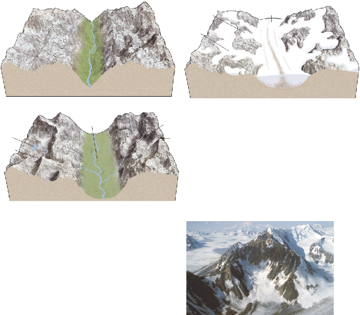
(a) Preglacial topography
(b) Maximum glaciation
U-shaped
valley
Hanging
valley
Horn
Tarn
Arête
Figure 17.16 Modification of mountainous landscapes
by glaciation.
(a) The preglacial topography of alpine re-
gions consists of rounded mountain slopes and a V-shaped
stream valley. (b) During maximum glaciation, well-defined
cirque glaciers shape mountain slopes and a thick valley gla-
cier fills the former stream valley. The valley glacier is fed by
tributary glaciers flowing into it. (c) The postglacial topogra-
phy is much sharper on the mountain slopes, and the former
V-shaped stream valley is rounded to a U-shaped valley.
(c) Postglacial topography
In many cases, cirques exist on several sides of an indi-
vidual mountain. Over time, these cirques may progressively
enlarge and steepen their respective side and headwalls so
that the ridges between them narrow and become quite steep
and thin, with serrated crests (Figure 17.18). Such a thin,
steep ridge is called an
arête
, the French word for “fish-
bone.” If a mountain has three or more arêtes resulting from
intersecting cirques, then the mountain is called a
horn
. The
most famous example of a horn is the Matterhorn in the
Swiss Alps.
Glacial erosion not only happens on high alpine peaks,
but also within the valleys that slope away from the ac-
cumulation zones of snow. Sometimes glaciers never leave
their cirque source areas, presumably because snow accu-
(a)
A sharp ridge that forms between two glacial cirques.
Arête
A mountain with three or more arêtes on its flanks.
Horn
Figure 17.17 Glacial cirques and tarns.
(a) Glacial cirques,
such as this one in the Canadian Rockies, are bowl-shaped de-
pressions created by the scouring action of glacial ice. (b) A tarn
is a meltwater lake that fills the depression within a cirque. This
one is located in the North Cascades of Washington State.
(b)