Geoscience Reference
In-Depth Information
Fan delta
Distributary channels
Birdfoot
delta
Alluvium
(b)
Sediment
plumes
Baton Rouge
(a)
New Orleans
4000-2000
yrs ago
2500-800 yrs ago
1000 yrs ago-present
5500-3800
yrs ago
7500-5000
yrs ago
0
50 km
Gulf of Mexico
0
50 mi
(c)
(d)
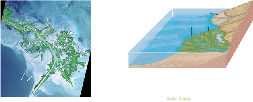
Figure 16.31 The Mississippi River Delta.
(a) This satellite image beautifully shows the Mississippi River's birdfoot delta. The delta
consists of a distributary network that funnels sediment (whitish hues) into the Gulf of Mexico. (b) The Mississippi River Delta is a complex
system of distributary channels that is underlain by copious amounts of sediment derived from the continental interior. (c) The Mississippi
Delta is a landscape of very low relief, consisting of numerous swamps and marshes that lie within a network of distributary stream chan-
nels. (d) Migration of the delta locations over the past 7500 years.
well-defined distributary network (Figures 16.31b and c).
Unlike the tributary system in the upper part of the drainage
basin, which funnels water into the trunk stream, the distribu-
tary network systematically drains water away from the main
channel into the ocean.
Such a network develops because the delta gradient is very
low and new channels form wherever a breach occurs in the
natural levee along the stream. Wherever these breaks occur
freshwater pours into the distributary bay, which subsequently
fills with alluvial sediment. When the bay ultimately fills, it
seals off and a levee breach occurs at another place in the delta.
This cycle occurs simultaneously at several places, which is
why the delta has the distinct distributary network. The entire
delta is underlain by enormous quantities of sediment (Figure
16.31b) that originated in places ranging from the Appalachian
Mountains to the Rocky Mountains. As you can see in Figure
16.31d, the location of delta formation has moved around in the
Deltas will be further discussed in Chapter 19 when we investi-
gate how coastal processes shape them.
KEY CONCEPTS TO REMEMBER ABOUT
ENTRENCHED MEANDERS, TERRACES,
AND DELTAS
1.
Entrenched meanders form when the slope of a
graded, meandering stream is increased through
extensive regional uplift, base-level drop, or climate
change.
2.
Alluvial terraces are abandoned floodplains that have
been elevated through the process of alluviation or
stream downcutting so that they are no longer fre-