Geoscience Reference
In-Depth Information
Bluffs
Bluffs
Terrace
Terrace
Floodplain
New floodplain
Alluvial sediment
(alluvium)
(a) Original floodplain
(c) New floodplain
Paired
Terraces
(b) River downcutting due to
regional uplift, base-level drop,
or climate change
(d)
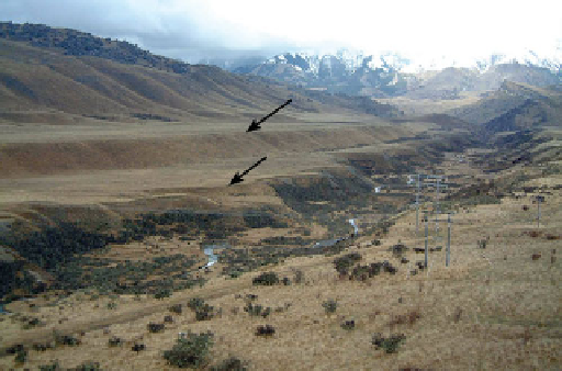
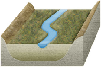
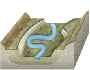
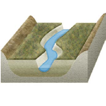
Figure 16.28 Formation of alluvial terraces.
Alluvial terraces form through a combination of meandering, flooding, and
downcutting in a river valley. (a) As the stream meanders, it creates an active floodplain that is underlain by alluvial sediment.
(b) During a period of downcutting, the formerly active floodplain is elevated with respect to the river; thus, it rarely floods and
a terrace forms. (c) A new active floodplain forms at a lower elevation when the stream begins to meander again. (d) Alluvial
terraces along the Cave River on the South Island of New Zealand. Notice that two terraces (arrows) occur along this valley,
which means that at least two periods of downcutting have occurred.
active floodplain, creating terraces on either side of the river that
are at the same elevation (Figure 16.28b). Such terraces are called
paired terraces
. Some of this older alluvial fill (that underlies
the terraces) may be removed by cutbank erosion if the stream
begins to meander again (Figure 16.28c). If the stream is able
to continue meandering
as
it downcuts, it may leave surfaces of
unequal elevation called
unpaired terraces
on either side of the
river. Many streams have numerous terraces that progressively
step down to the river (Figure 16.28d). Whenever you see such a
sequence of surfaces, it indicates that the stream has had a very
complex history of flooding and downcutting.
lic variables, and the type of landforms you would see along
the stream's profile (Figure 16.29). Stream gradient is highest
in the upper reaches of the system, which translates to greater
velocity in these areas and higher
stream power
. It also has
high
stream competence
because it is capable of carrying large
particles, perhaps even boulders, at high flows. As a result, the
stream expends its energy vertically, and well-developed gullies
and canyons appear in this part of the watershed due to exten-
sive erosion. Given that the streams here are low-order systems,
however, their width and depth are relatively small because
they contain little water compared to higher-order streams. This
means that discharge is also relatively low in streams in this part
of the drainage basin.
As we move farther downstream into the middle reaches
of the profile, notice that slope decreases, which causes
stream velocity to drop correspondingly. As a result, the
stream has less power and thus begins to meander rather
than downcut. This shift results in valley widening in this
part of the system. Width, depth, and discharge also in-
crease because streams in this reach have a higher order due
A Holistic View of the Graded Stream Model
At this
point in the chapter, the concepts of stream order, hydraulic
variables, stream behavior, and fluvial landform evolution have
been discussed. With these concepts in mind, it is now useful to
integrate them into a holistic framework that links them within
the graded stream model. Remember that once a stream reaches
a graded condition, it has the idealized longitudinal profile seen
in Figure 16.20a. After this condition is reached, a very close