Geoscience Reference
In-Depth Information
more energy than sediment load. When a stream becomes
graded, however, it no longer needs to downcut through-
out the entire system because it has reached a gradient on
which it can transport the average load that is provided from
the hillslopes in the upper reaches of the system. Although
downcutting may continue in the upper reaches of a water-
shed where the gradient is steep, the stream begins to expend
its energy in a horizontal fashion in the lower reaches where
the gradient is less.
Stream Meandering
As noted previously, streams mi-
grate horizontally through a process called meandering, in
which numerous pronounced arcs and curving bends develop
in the valley (Figure 16.22d). Stream meanders are fascinat-
ing places because both erosion and deposition occur si-
multaneously. As a result, stream meanders move back and
forth across the valley over time. Figure 16.24 shows the
processes associated with a typical stream meander. As the
river flows around the meander bend, the centrifugal force
associated with its current carries the main line of flow of
the channel, or
thalweg
, to the outside of the curve. Thus,
the channel is deepest and the flow velocity is highest in this
part of the stream. Given the high stream power that exists
on the outside of the meander, this part of the arc is a zone
of aggressive erosion. As a result, the surface leading away
from the river is undercut, which causes the overlying sedi-
ment to collapse into the stream, forming a steep slope called
a
cutbank
. Erosion also scours the channel bottom at these
locations, forming deep
pools
. At the same time that erosion
shapes the cutbank, deposition occurs on the inside of the
meander bend because the channel is shallow in this part and
energy is low. As a result, alluvium accumulates as a long,
curving deposit of sediment called a
point bar
that is only
about 1 m (about 3.3 ft) above the level of the stream.
If you are looking for clues as to whether a stream is ac-
tively meandering, a good piece of evidence is the presence of
oxbow lakes in a stream valley. An
oxbow lake
is a water-filled
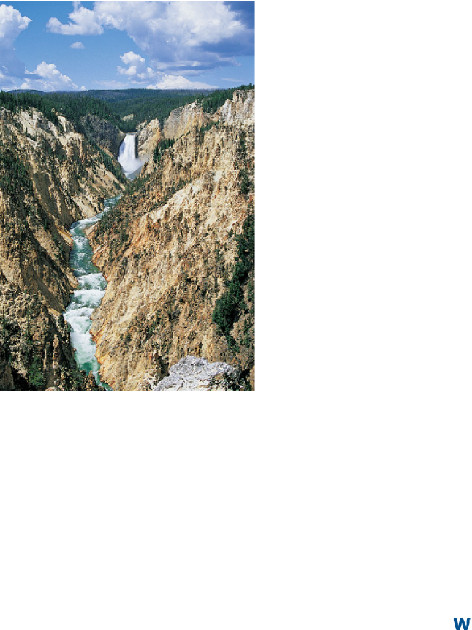
Figure 16.23 The Grand Canyon of the Yellowstone River.
Here, the Yellowstone has yet to reach a graded condition, as
indicated by the deep V-shaped canyon and waterfall. Compare
this photograph with Figure 16.22b.
headward erosion is occurring, the canyon continues to be
more deeply incised.
Look at Figure 16.22d. The stream valley looks different
from its appearance in the previous three images. Now, the
valley is no longer V-shaped but is quite wide. This change is
evidence that the stream has reached a graded condition and
has the graded longitudinal profile seen in Figure 16.20a.
Recall that during the early stages of stream valley evolution
the stream erodes vertically because it has proportionately
Oxbow lake
A portion of an abandoned stream channel that
is cut off from the rest of the stream by the meandering process
and filled with stagnant water.
Stream Meandering
To view an animation on the meandering process, go to the
Geo
Media Library
and access
Stream Meandering
. This anima-
tion illustrates how meander bends form over time in an initially
straight river and also shows the formation of an oxbow lake.
As you watch this animation, relate it back to the evolution of
a stream valley. Once you complete the animation, be sure to
answer the questions at the end to test your understanding of
this concept.