Geoscience Reference
In-Depth Information
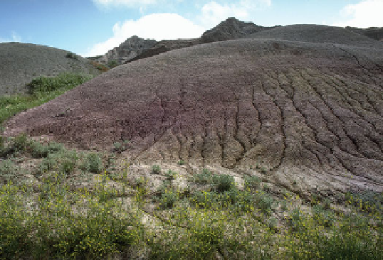
formation of tiny furrows in the ground called
rills
that look
like parallel seams on the slope (Figure 16.17a). These rills,
in turn, begin to merge as stream power and erosion intensi-
fies, forming larger and deeper ditch-like features called
gul-
lies
(Figure 16.17b).
Sediments eroded from hillslopes by overland flow are
either deposited quickly or carried to a stream where they
can be transported great distances. Deposition of eroded
slope sediments often takes place at the base of the hill
where the slope becomes gentler, the effect of gravity less-
ens, and less power is available to carry sediment. Recall
from Chapter 14 that sediment deposited in this manner is
called
colluvium
and can form an apron-like landform that
may be difficult to distinguish in humid regions of dense
vegetation.
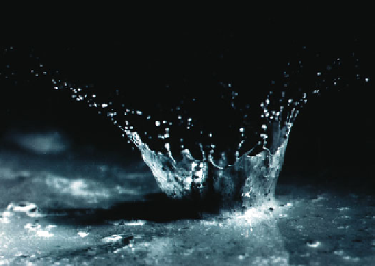
Figure 16.16 The process of splash erosion.
Splash erosion
occurs because large raindrops create a small crater when they
impact on bare soil.
process creates some distinctive landforms. The most prominent
feature is a
peak
, which is the highest point on any given moun-
tain. Peaks are typically separated by a lower landform called
a
saddle
. As streams cut into the mountain slopes, they first
create a shallow
gully
, which can enlarge to become a
ravine
and then, if sufficient time and erosion later occur, a deep and
broad
canyon
. These features are separated from one another
by a relatively high ridge called a
spur
, which is, in effect, a
drainage divide. Over time, the eroded hillslope sediments are
transported into the valley below, where they may be deposited
on more level terrain within an
alluvial fan
or
river floodplain.
.
Here the relief lessens and geomorphic processes lose their
power. These landforms will be described in more detail later
in the chapter.
(a)
Fluvial Erosion on Hillslopes
The logical place to begin a
discussion of stream erosion is by focusing on hillslopes, which
are the part of the landscape that is most intensely eroded by
running water. Hillslopes are the most active zones of fluvial
erosion because, as indicated before, the force of gravity is
greatest in areas of high relief, which, in turn, causes running
water to flow more quickly and thus with more energy. Sedi-
ment transport begins on hillslopes as soil erosion, initiated
when the fluid drag associated with overland flow picks up sedi-
ment. In humid regions, dense vegetation protects slopes, and
erosion occurs sufficiently slowly that the soil maintains all its
horizons. However, the process of slope erosion accelerates in
more arid regions, deforested areas, and agricultural fields be-
cause raindrops fall directly on bare soil. When this pounding
occurs, sediment is loosened, lifted, and dropped into new posi-
tions through a process called
splash erosion
(Figure 16.16).
It subsequently begins to flow down the slope as sheet runoff,
mentioned earlier.
As sheet flow moves across the surface, the total water
volume and degree of turbulence increase down the slope.
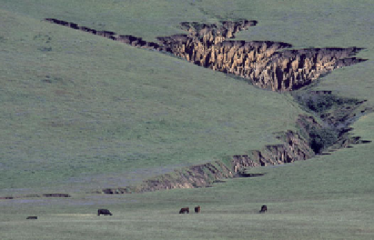
(b)
Figure 16.17 Formation of rills and gullies.
(a) Rills are small
channels that evolve when heavy rains fall on hillslopes. (b) This
gully formed due to the enlargement and merging of rills as a re-
sult of rapid runoff.