Geoscience Reference
In-Depth Information
Figure 16.13 Meteorology of 1993 flood.
A high-pressure system stalled over the
southeastern United States and persis-
tently pumped humid mT air into the upper
Midwest. This water vapor condensed and
fell as rainfall along the stalled frontal bound-
ary in the region. This intense rain caused
widespread flooding.
Cold/dry cP air
from Canada
Area of converging
air masses
Jet stream stalled over Midwest
Mississippi
River drainage
basin boundary
Southeastern
high
Warm/moist
mT air from
Gulf of Mexico
(4 in. and 6 in.) of rain fell in a broad swath of southeastern
Iowa. This kind of rain event was a common occurrence that
summer as the region received over
200%
of normal precipi-
tation for that time of year!
Given that the soils of the region were already saturated
from the wet winter, most of the rainfall could not be absorbed.
As a result, flooding was widespread, affecting most of the ma-
jor streams and tributaries in Iowa, southeastern Wisconsin,
western Illinois, northern Missouri, eastern Nebraska, and
northeastern Kansas. Since all these streams progressively
merge and ultimately flow into the Mississippi River, flooding
along this stream was intense (Figure 16.14).
KEY CONCEPTS TO REMEMBER ABOUT
STREAM HYDROLOGY
1.
Stream flow in a channel is defined by its hydraulic
variables, including width, depth, velocity, slope, and
discharge.
2.
Hydraulic variables are interrelated with one another.
For example, stream discharge is calculated by the
equation
Q
â
w
ñ
d
ñ
v
. Increased slope results in
faster-flowing streams.
(a)
(b)
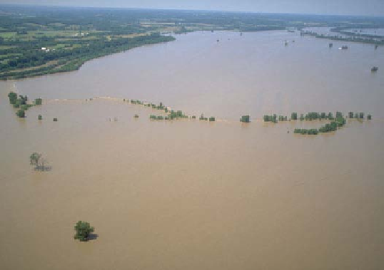
Figure 16.14 Flooding along the Mississippi River in 1993.
(a) Aerial photograph of flooding along the Mississippi River in 1993.
(b) Landsat images of the confluence of the Missouri and Mississippi Rivers north of St. Louis during a normal year (left) and during 1993