Geoscience Reference
In-Depth Information
become open when the water table falls, usually in as-
sociation with stream downcutting or climate change.
kEY CONCEPTS TO REMEMBER ABOuT
kARST LANDSCAPES
3.
Once caves are opened, drip processes form features
such as stalagmites and stalactites.
1.
Karst landforms and landscapes form in association
with groundwater and include features such as caves
and sinkholes.
4.
Sinkholes are surface depressions that result when
underlying caves collapse, causing subsidence.
2.
Caves begin to form during a period of high water table
when flowing groundwater dissolves carbonate-rich
limestones through the process of carbonation. Caves
5.
Tower karst forms in humid areas when numerous sink-
holes and collapse structures develop, leaving promi-
nent hills rising above the landscape.
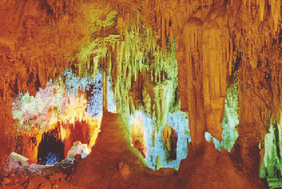
VISUAL CONCEPT CHECK
15.2
Given what you see in this photograph,
which one of the following statements is
accurate?
a)
The local water table intersects with
the ground level at this place.
b)
This photograph shows the formation
of tower karst.
c)
The top of a cave collapsed, forming a
sinkhole.
d)
The local water table was much higher
at some point in the past.
S U M M A R Y O F K E Y C O N C E P T S
1.
Groundwater refers to water that is stored within the
ground. Some water is stored in soil pore spaces to form
the soil-water belt. If the soil and associated pores are
saturated, water is free to move downward under the
force of gravity. When water percolates downward, it
first encounters the unsaturated zone.
3.
Groundwater can become contaminated when chemicals
from old landfills or dumps slowly move into the system.
4.
Karst landforms and landscapes form in association with
groundwater and include features such as caves and
sinkholes.
5.
Caves begin to form during a period of high water ta-
ble when flowing groundwater dissolves carbonate-rich
limestones through the process of carbonation. Caves
become open when the water table falls, usually in as-
sociation with stream downcutting or, perhaps, climate
change.
2.
At some depth the sediment pore spaces are satu-
rated with water, forming the saturated zone. The
sediments in this zone usually consist of sand and
gravel that are underlain by an aquiclude of imperme-
able clay or shale. The top of the saturated zone is
called the water table. In places where the ground-
water supply is sufficiently large for people to use
for irrigation or drinking water, the saturated zone is
called an aquifer.
6.
Tower (or haystack) karst topography forms when numer-
ous caverns and subterranean passageways collapse,
leaving individual high hills.