Geoscience Reference
In-Depth Information
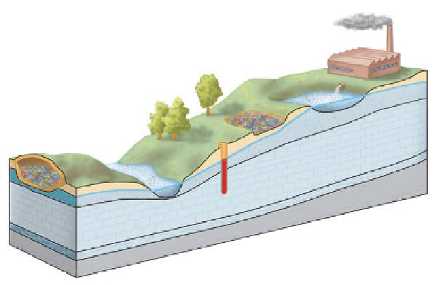
Figure 15.9 Movement of groundwater
contaminants.
Infiltrating water at solid-
waste disposal sites, such as waste ponds
and unregulated landfills, carries toxic
chemicals into the groundwater, which
flows along natural pathways to pollute
wells and streams.
Waste pond
Unregulated
landfill
Factory
Contaminated
well
Regulated
landfill
Water
table
Saturated
(porous)
layer
Contaminated
stream
Flow of
toxic
chemicals
Impermeable
layer
Flow of
clean water
tion by pollutants. Our industrial society produces enormous
amounts of solid and liquid waste. Until the latter half of the
20th century, no regulations governed the disposal of this
waste. As a result, much of it was simply carted off to large
holes in the ground, some excavated and some natural, where
it was perhaps burned and buried. Infiltrating rainwater would
interact with chemical compounds in the waste and carry
pollutants into the saturated zone, where they would then flow
along the various groundwater paths to wells and streams (Fig-
ure 15.9). Given that drinking water is often obtained from
groundwater, contamination can be a significant health risk.
Since the establishment of the Environmental Protection
Agency (EPA) in the mid-1970s, a more systematic effort has
been made to control the disposal of solid waste in the United
States. One important way in which solid-waste disposal is in-
tensely regulated by the EPA occurs in highly engineered land-
fills. In contrast to the traditional “hole-in-the-ground” approach
used previously, modern engineered landfills are designed to
eliminate the flow of toxic chemicals and other contaminants
into the groundwater supply. For example, landfill engineers
can line the base and sides of the landfill with impermeable
material so that groundwater contamination is minimized. Any
toxic chemicals and contaminants produced in the landfill are
pumped to a settling pond where the waste is oxidized and neu-
tralized. In spite of these measures, landfills and other hazard-
ous waste facilities often remain very controversial.
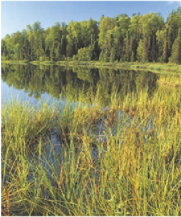
VISUAL CONCEPT CHECK
15.1
This photograph shows the shoreline of a natural lake.
Given what you see here, which one of the following state-
ments is accurate?
a)
The shoreline represents the place where the ground
level meets the local water table.
b)
The water table lies below the level of the lake bottom.
c)
The local water table is very low.
d)
A tremendous amount of groundwater mining has oc-
curred in the area.