Geoscience Reference
In-Depth Information
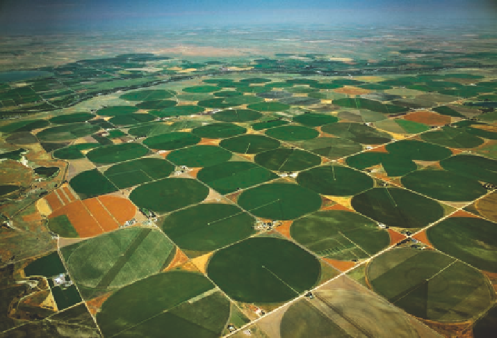
Figure 15.6 Aerial view of center-pivot
irrigation.
Center-pivot pumping systems
such as these in Colorado were developed
in the mid-20th century and are almost ubiq-
uitous now in parts of the Great Plains. Each
circle is about the size of a 1/4 section in the
USPL system discussed in Chapter 2. Look
for them when you fly over the country.
Second, settlers also noticed that many streams had a fairly con-
sistent supply of water in them, even during periods of relative
drought. This consistent flow resulted because stream channels
intersected with the aquifer's water table, providing a steady
source of water. These patterns are common not just to the High
Plains Aquifer, but to any place where the water table is high
and intersects depressions and streams.
For the first half of the 20th century, access to the High
Plains Aquifer was limited and largely confined to artesian and
hand-excavated wells. However, the access to water changed
dramatically in the early 1950s with the advent of a new tech-
nology called
center-pivot irrigation
. Center-pivot systems
consist of motorized pumps that tap into the aquifer and suck
up water like drinking from a straw. They then distribute the
water to farm fields through an elevated sprinkler system that
extends to the edge of the field. This sprinkler system slowly
rotates around the pump on a set of wheels so that the field
is consistently supplied with water. Most such systems cover
a circular area approximately 64 hectares (160 acres) in size,
although some are larger.
Development of center-pivot systems was a major advance-
ment for the agriculture-based economy of the region, enabling
farmers to control the semi-arid environment by providing a
reliable supply of water to high-yield crops such as corn that
would otherwise not consistently grow there. These systems
have been so wildly successful that tens of thousands of them are
currently in operation around the region, forming a patchwork
of circles that are easily seen from the air (Figure 15.6). The
next time you fly across the country, be sure to notice this im-
portant part of the nation's cultural landscape and consider how
it supplies much of your food. Also consider the massive human
footprint on the landscape and how it relates to Chapter 10 and
the discussion of the Anthropocene as a potential epoch in the
geological timescale.
Although the rapid expansion of center-pivot irrigation has
enabled farmers to be successful in marginal regions such as
the High Plains, the long-term environmental consequences of
extensive groundwater mining in the region are significant. The
most obvious impact of extensive groundwater extraction is that
the water table has dropped in many places because so much
water has been withdrawn. According to the U.S. Geological
Survey, 17 billion gallons of water were drawn for irrigation
purposes every day in 2000. Another 315 million gallons were
withdrawn to supply water for almost 2 million people living
in the region. Such a rate of withdrawal far exceeds the rate
of recharge, meaning that groundwater levels must inevitably
decline. This decline can be seen at the local level with any
individual well as a
cone of depression
in which water is
drawn down in a circular pattern from the aquifer surrounding
the well (Figure 15.7a). If pumping from the well ceases, the
cone will fill back in, both by recharge from the surface and
by water seeping into the empty pores from the surrounding
saturated zone.
In many regions, however, groundwater extraction is in-
creasing because more wells are being installed and water is used
year-round for farming and ranching. As a result, the drain on un-
derground water has become serious across the region, as well as
in many other parts of the world. Figure 15.7b shows the impact
that two wells—a deep well and a shallow, seasonal well—may
have on the groundwater supply in a particular area. In the Great
Plains of North America, such drawdown has occurred in thou-
sands of places, causing a significant decline in the elevation of
the water table in many locations. In areas within southwestern
Cone of depression
The cone-shaped depression of the
water table that occurs around a well.