Geoscience Reference
In-Depth Information
was convicted of involuntary manslaughter for “an assess-
ment of the risks that was incomplete, inept, unsuitable, and
criminally mistaken.” As a result, they were sentenced to six
years in prison and prohibited from ever holding public of-
fice again. The conviction caused a furor in the global sci-
entific community because it appeared that the defendants
were convicted of failing to predict an event that is unpre-
dictable. Some saw much broader implications for science
as a whole, arguing that penalizing scientists for making
what turns out to be incorrect predictions or for not predict-
ing something that does occur will restrict research to safe
certainties. Others argued, however, that the defendants in-
deed did a poor job communicating the overall seismic risk
in the area and had failed in that regard.
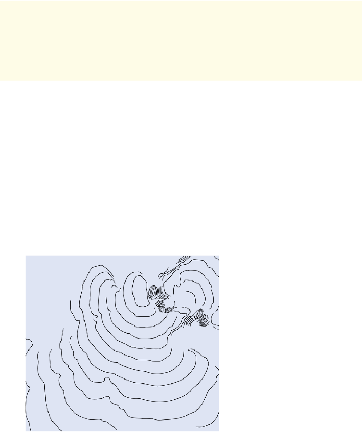
tip of South Africa, which is about 8500 km (5300 mi) to the
southwest, in about 12 hours (Figure 13.29). Coincidentally, a
French radar satellite happened to pass over the Indian Ocean
2 hours after the earthquake and measured the tsunami wave
heights as they moved across deep water. These observations
indicated that the maximum wave height in the open ocean
was only 60 cm (2 ft), which would have scarcely been no-
ticed by ships in the area. As the waves approached the shore,
however, they grew rapidly due to the shallow water, reaching
an estimated height of 24 m (80 ft) at Banda Aceh in the north-
west coast of Sumatra. Some of the tsunami's energy spread
into the Pacific Ocean, even creating a tsunami along the west
coasts of North and South America that measured from 20 cm
to 40 cm (7.9 in. to 15.7 in.) in height.
Following the Indonesian tsunami in 2004, yet another
tsunami was triggered in March 2011 along the coast of Japan
by a magnitude 9.0 earthquake. This quake, which is known as
the
2011 Tohoku earthquake
, occurred where the Pacific plate
is subducting under the plate beneath northern Honshu. It was
the fourth largest earthquake measured on Earth since 1900
and was preceded by a number of strong (up to magnitude 7.0)
foreshocks in the previous couple of days. The epicenter of
the main event was located about 70 km (40 mi) east of the
Oshika Peninsula (Figure 13.30a) and occurred at a fairly
shallow depth of about 29 km (19 mi). It lasted approximately
six minutes and moved parts of northeastern Japan up to 2.4 m
(7.9 ft)
closer
to the coast of North America. The amount of
slippage along the fault was perhaps as much as 40 m (130 ft)
in some places, and the seafloor was instantaneously raised up
to 7 m (23 ft) along the fault.
As a result of the raised seafloor, water was quickly dis-
placed above the fault in much the same manner as the uplift
that produced the Indonesian tsunami. The resulting tsunami
reached the shore of Japan in less than an hour, was up to 6 m
(20 ft) high in places (Figure 13.30b), and inundated 560 km
2
(217 mi
2
) of the Japanese coast. The tsunami rippled across
the Pacific Ocean and reached the coast of North America in
about 9 hours. Surges up to 2.4 m (8 ft) occurred along the
coasts of Oregon and California, damaging docks and mari-
nas to the tune of about $10 million in losses. Tsunami waves
reached the coast of Chile about 22 hours
after the earthquake but caused relatively
minor damage.
The impact of both the Indonesian and
Japanese tsunamis on coastal communities
was devastating. Video from numerous sites
during both events illustrated the incred-
ible power of moving water. In each case
these clips showed several waves—best de-
scribed as enormous surges of water—that
completely engulfed coastal communities
(Figure 13.30b) while blasting everything in
the way (Figure 13.31). The energy released
by the Indonesian tsunami is estimated to
have been equivalent to about 5 megatons of
TNT, which is
more than all
of the explosive
energy used during World War II (including
30 N
10
Maldive
Islands
India
Thailand
Somalia
Sri
Lanka
0
1
Sumatra
I n d o n e s i a
2
3
Madagascar
4
South
Africa
Australia
30 S
5
6
7
8
10
9
Figure 13.29 Travel time in hours for the 2004
tsunami in the Indian Ocean.
The tsunami
reached the shores of Indonesia and Thailand
within minutes of the earthquake. In contrast,
it reached the southern tip of South Africa in
about 12 hours. (
Source
: NOAA.)
60 S
10
30 E
60 E
90 E
120 E
150 E