Geoscience Reference
In-Depth Information
Rock Name
Age (Years/Depositional Environment)
Kaibab limestone
Toroweap formation
Coconino sandstone
Hermit shale
~ 250 million/Shallow sea
~ 260 million/Shallow sea, coastline
~ 270 million/Sand dunes
~ 280 million/Mud near shore
Supai group
~ 300 million/Above water coastline
Redwall limestone
Temple Butte formation
Mauve limestone
Bright Angel shale
Tapeats sandstone
~ 330 million/Shallow sea
~ 350 million/Streams near shore
~ 530 million/Shallow sea
~ 540 million/Coastline
~ 550 million/Coastline
~ 2 billion- 824 million/Old metamorphic rocks,
Precambrian
rocks, inner
gorge
young sedimentary rocks
Colorado river
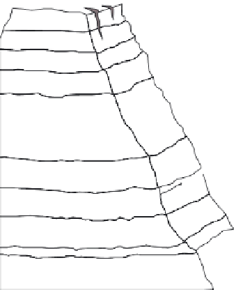
Figure 12.21 Rock layers in the Grand Canyon.
Many different kinds of rocks are exposed in the Grand Can-
yon, Arizona, reflecting several kinds of depositional environments that have occurred in the region over time. Note
the relationship between the rock type and the kind of place in which the sediments originally collected.
After the last Precambrian sediments accumulated,
another lengthy period of erosion occurred. This period lasted
about 300 million years and is called the
Great Unconformity
because no rocks from this period exist. Geologists believe that
rocks were almost certainly there, but they were eroded by an
advancing sea sometime late in that interval of time. The rocks
above the Great Unconformity consist of alternating layers of
sandstone, shale, and limestone that collectively accumulated
between 550 and 250 million years ago. These rocks are testa-
ment to fluctuating sea levels that resulted in the deposition of
South
Dakota
Wyoming
Nebraska
Great Plains
Colorado
Utah
Spanish Peaks
Sangre de Cristo Mts.
(b)
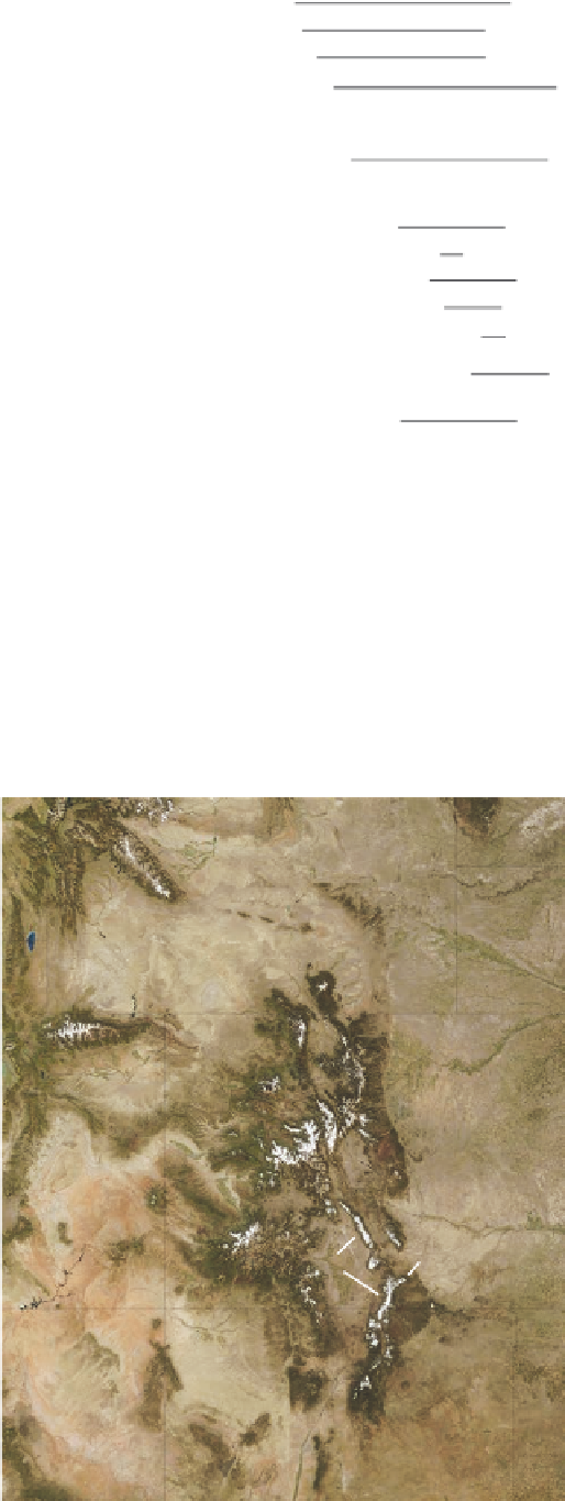
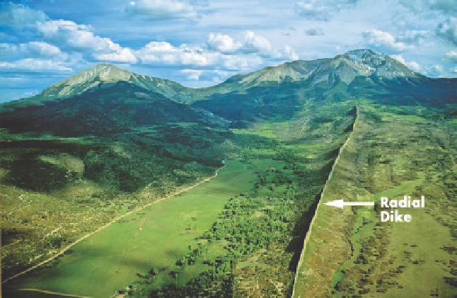
Figure 12.22 The Spanish Peaks in southern Colorado.
(a) This
true color satellite image of Colorado and adjacent states shows the
location of the Spanish Peaks. This image was acquired in Septem-
ber 2002 and shows the first snow of that year, which can be seen
as white on the mountain crests. (b) Looking south at the Spanish
Peaks. The crest of East Spanish Peak (left) is 3866 m (12,683 ft)
high, whereas the top of West Spanish Peak (right) is 4153 m
(13,626 ft) in elevation. Note the prominent radial dike that extends
to West Spanish Peak. Several dikes like this one occur in the area.
New Mexico
Arizona
(a)