Geoscience Reference
In-Depth Information
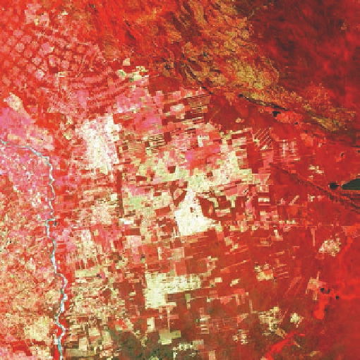
VISUAL CONCEPT CHECK
10.3
This pair of infrared satellite images is of the same region in the Amazon rainforest at different times.
Remember that red on this kind of image represents vegetation. The (a) image was acquired in 1975,
whereas the (b) image dates to 2000. The difference that you see reflects extensive deforestation along
road networks in the region. Which one of the following statements is accurate with respect to the impact
that this kind of deforestation has on global climate change?
a)
Fewer trees will result in the production of more oxygen.
b)
The amount of atmospheric carbon dioxide will increase because fewer trees are present to
absorb it.
c)
Global temperature should decrease given that fewer trees are present in the rainforest.
d)
There will be less atmospheric carbon dioxide because trees produce carbon dioxide as a
by-product of respiration.
(a)
(b)
Remote Sensing and the Biosphere
Plant ecologists and geographers are very interested in the pat-
terns and rates of vegetation change on Earth. In this context,
one of the ways that plant geography is studied and monitored
is with remote sensing. To provide a sense of how this form of
monitoring can be done, go to the
Geo Media Library
and se-
lect
Remote Sensing and the Biosphere
. Within this interac-
tive module, you will be able to analyze (1)
Land Productivity
,
(2)
Ocean Productivity
, and (3)
Fire Patterns
. In each of these
submodules, you will be presented with a series of satellite im-
ages and prompts to identify specific features on imagery. Once
you complete the interactivity, be sure to answer the questions
at the end to test your understanding of the concepts contained
within it.