Geoscience Reference
In-Depth Information
Saffir-Simpson Scale of Hurricane IntensityT
T A B L E 8 . 2
Category
Central Pressure, mb
Mean Wind, m/sec (mph)
Storm Surge, m (ft)
1 Weak
33-42 (74-95)
1.2-1.7 (4-5)
> 980
2 Moderate
965-979
43-49 (96-110)
1.8-2.6 (6-8)
3 Strong
945-964
50-58 (111-130)
2.7-3.8 (9-12)
4 Very strong
920-944
59-69 (131-155)
3.9-5.6 (13-18)
5 Devastating
< 920
> 69 (> 155)
> 5.6 (> 18)
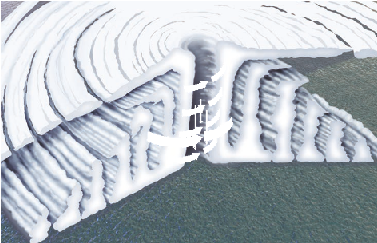
Figure 8.24 shows the typical anatomy of a hurricane. Note
the distinct bands of cumulonimbus clouds, which can drop
prodigious amounts of rainfall, surrounding the core of the
system. Also observe that air flows inward at the surface to a
point where it rapidly flows upward at the eye wall. Remember
that the entire time the air is flowing inward and upward, it is
spinning cyclonically at intense speed. A unique characteristic
of a well-developed hurricane is the eye, which occurs in the
center of the storm and is associated with high-pressure air that
rapidly flows toward the surface and warms adiabatically as it
descends. As a result, this region of the storm is cloud-free with
no winds and can be seen in satellite images of well-developed
hurricanes.
Because hurricanes evolve in the easterly trade belt, they
migrate in a fairly predictable way. Figure 8.25 shows typical
tracks that hurricanes take in August. Notice that many of the
storms originate in the eastern Atlantic Ocean. These storms
actually begin to organize when they exit western Africa as
easterly waves in the trade-wind belt. When they reach the open
warm waters of the eastern Atlantic, they begin to intensify, first
as tropical depressions, then as tropical storms, and finally, if
conditions are favorable, into hurricanes. The systems continue
to migrate westerly, sometimes strengthening, at other times
weakening. If the storm remains organized for several days, it
ultimately becomes influenced by the midlatitude westerlies
and is deflected to the northeast.
Human Interactions:
Coping with Destructive Hurricanes
As you can see in Figure 8.25, many storms remain over open
water throughout their entire history. A few, however, strike
land at some place in the Caribbean Sea, Gulf of Mexico, or
the Atlantic seaboard in the United States. In most cases these
landfall hurricanes are category 1 or 2 storms that, while pack-
ing a strong punch, usually blow through fairly quickly with-
out causing too much chaos. Occasionally, however, stronger
storms hit that result in catastrophic damage over a broad area
and numerous human fatalities. Some of these storms are in-
famous, such as the 1900 hurricane that killed over 6000
High-level winds spiral outward
Descending dry air
Eye wall
Figure 8.24 Components of a typical
hurricane.
Hurricanes contain numer-
ous spiral rain bands of cumulonimbus
clouds. Air spirals inward until it reaches
the eye wall, where it circles upward.
The eye of the storm is clear and calm,
which is the result of air descending and
adiabatically warming in the core of the
system.
Spiral bands of rain
High-speed winds
spiral upward
around eye
Concentric rings of
cumulonimbus clouds