Geoscience Reference
In-Depth Information
D I S C O V E R …
FASCINATING CLOUDS ASSOCIATED
WITH THUNDERSTORMS
In addition to strong wind, lightning, and thunder, powerful
thunderstorms sometimes produce fascinating cloud pat-
terns diagnostic of distinct meteorological processes. One
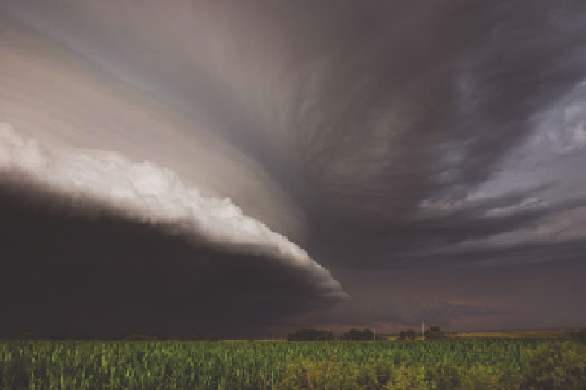
such cloud formation is a
shelf cloud
like the one pictured
here. A shelf cloud develops when a cold downdraft within a
storm surges outward along the ground after it reaches the
surface. As it does so, it lifts the relatively warm and moist
air ahead of the storm up to the level of condensation, form-
ing this shelf-like feature. Such a cloud is often accompa-
nied by a cold gust front.
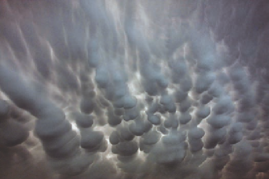
Another interesting and diagnostic cloud formation as-
sociated with thunderstorms is
mammatus clouds
. Also
known as
mammatocumulus
, which means “mammary
cloud,” mammatus clouds look like pouches or lobes hang-
ing eerily upside down in the air like those shown here.
These clouds are usually found on the base of a spread-
ing anvil downwind of a large thunderstorm. Their forma-
tion is poorly understood but may be somehow related to
overturning pockets of colder air that descend into warmer
air at high altitudes. Although they are usually composed of
ice, they also contain liquid water and can seem translucent.
Mammatus clouds are more common during warm months
and are more often seen in the Midwest and the eastern
parts of the country.
drafts known as
mesocyclones
(Figure 8.15) that range from
3.2 km to 9.7 km (2 mi to 6 mi) in diameter. When these at-
mospheric conditions occur, they can easily evolve to include
tornadoes, which are small, but deep, low-pressure cells sur-
rounded by a violently spinning mass of air. Although gener-
ally less than 400 m (0.25 mi) in diameter, tornadoes are the
most destructive of all atmospheric phenomena, with wind
speeds ranging from 160 to 480 km/h (100 to 300 mph). These
high speeds occur because tornadoes have extremely tight
pressure gradients that may differ by 100 mb between the in-
side and outside of the funnel. Between 1971 and early 2007,
tornadoes were classified according to the Fujita scale based on
the amount of damage caused. Acknowledging that the qual-
ity of building construction can vary and thus give mislead-
ing conclusions about wind speed, the
Enhanced Fujita Scale
was implemented in February 2007. This classification system
is based on the speed of winds at 3-sec gusts at the point of
damage (Table 8.1), ranging from the EF0 tornado to the rare
EF5 tornado.
Figure 8.16 shows the evolution of a tornado. Tornadoes
usually form at the rear of a storm when strong updrafts occur
in conjunction with wind shear at higher altitudes. Wind shear
occurs when winds are moving in different directions at vari-
able altitudes. This wind shear causes a horizontal vortex of air
to form (Figure 8.16a) that is then pulled vertically in the up-
draft (Figure 8.16b). Assuming this process is not interrupted, a
funnel develops that becomes a full-fledged tornado if it reaches
Mesocyclones
Strong updrafts that rotate within a supercell
thunderstorm.