Geoscience Reference
In-Depth Information
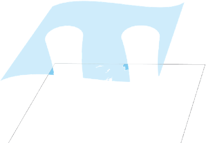
Convergence
Upper level
(500 mb)
airflow
Divergence
Rising air;
low surface
pressure
Sinking air;
high surface
pressure
Figure 8.7 Linkage of upper air-
flow and surface airflow in a mid-
latitude cyclone.
These systems
form through a complex interaction
of upper airflow and surface airflow.
Under the high-pressure system,
the weather is stable with clear sky.
Where the cyclone forms, however,
the atmosphere is unstable.
Surface
airflow
H
L
Anticyclonic flow
Cyclonic flow
high-pressure ridge
. In contrast, the height of the pressure
surface is lower in the areas associated with the low-pressure
systems along each coast. Meteorologists call these valley-
like features in the 500-mb surface
low-pressure troughs
.
Regardless of whether the upper atmospheric pressure system
is a ridge or a trough, each shares the common reference of
an axis, which is the imaginary line that extends along their
length, that is, from north to south.
When this condition develops, the upper airflow becomes dis-
turbed, with a region of converging airflow developing behind
(to the left of) the trough axis in Figure 8.7. At the same time, a
zone of diverging air forms east (to the right) of the trough axis.
As these airflow patterns continue to develop, the air pressure
beneath them (at ground level) changes. At places where the
air converges aloft, more air flows into a given unit of space
at the 500-mb level. This convergence forces air toward the
surface as a zone of high pressure. In contrast, where the air
diverges aloft on the downwind side of the trough, less air is
occupying a given unit of space, which has the effect of pulling
air up from beneath to fill the void. When this situation occurs,
the surface and upper airflows become closely linked as col-
umns of spinning air—in other words, a dynamic convection
loop—that are set in motion by the Coriolis force, as described
in Chapter 6.
To understand better how midlatitude cyclones form and
how they influence the weather on the ground, let's investigate
the system evolution at the surface by studying the section of the
polar front outlined in Figure 8.8. Notice that prior to the devel-
opment of a midlatitude cyclone, the polar front is linear, with
parallel-flowing and opposing winds—cold, easterly winds to the
north of the front and warm westerly winds to the south.
Interaction of Upper Airflow
and Surface Airflow
In the context of understanding how midlatitude cyclones form,
it is useful to examine the interaction of airflow on the ground
with airflow at the 500-mb pressure surface. As we begin this
part of the discussion, follow along by studying Figure 8.7,
which shows airflow both on the ground and at the 500-mb
altitude. This figure is very similar to Figure 6.12 because it
shows a dynamic convection loop in the atmosphere, but differs
because it is viewed within the context of the 500-mb surface.
Let's imagine a scenario in which a prominent Rossby
wave exists in the upper atmosphere and a low-pressure trough
has developed poleward of the jet stream at the 500-mb level.
High-pressure ridge
An elongated area of elevated air pres-
sure in the upper atmosphere that is typically associated with
sunny skies and calm winds.
Low-pressure trough
An elongated area of depressed air
pressure in the upper atmosphere that is typically associated
with cloudy skies and rain.