Geoscience Reference
In-Depth Information
from the mountain crest, its maximum humidity increases while
the specific humidity remains constant. In other words, the air is
no longer saturated and thus warms at the DAR. The air warms
at this rate from the crest of the mountain range at point 3, to
an elevation of 0 m (0 ft) in the leeward valley at point 5. Given
the high temperature of the air mass at this point, coupled with
the very low relative humidity, the leeward side of the mountain
range is dry and therefore called the
rain shadow
.
The orographic pattern just described can result in a fas-
cinating range of landscape variability in a relatively small
geographical area, from windward slopes that receive abundant
precipitation to leeward slopes that are very dry. A good place
to see the results of these processes over a short distance is in
California. Figure 7.24a shows the assemblage of landform re-
gions of the state, including (from west to east) the low Coast
Ranges, broad Great Valley, and high Sierra Nevada (moun-
tains). The prevailing winds are westerly in the region, bringing
in moisture-laden air with high dew points off the Pacific Ocean
to the west. Notice that air flows over the Coast Ranges, down
into the Great Valley, and then up and over the Sierra Nevada.
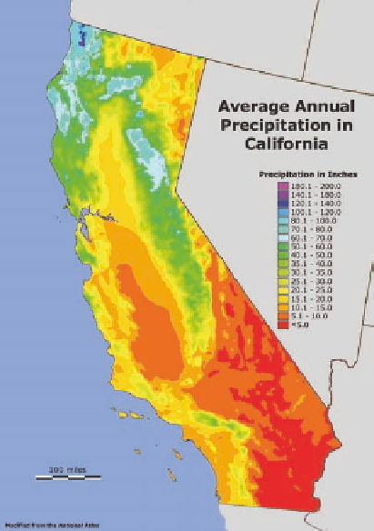
Figure 7.24b shows mean annual precipitation in the region.
What patterns do you see? For one, observe that annual precipita-
tion is high along the Coast Ranges and Sierra Nevada, with val-
ues reaching 180 cm (about 70 in.) in the central Sierras. Much
of this precipitation falls as snow, which can reach depths of over
20 m (68 ft) at the highest elevations during a snowy winter! In
contrast, the Great Valley is a distinct rain shadow, with only
40 cm (16 in.) compared to the 200 cm (80 in.) that falls in some
parts of the mountains to the west. This valley will be discussed
in more detail in Chapter 20 when agriculture in California is ex-
amined. Another rain shadow exists east of the Sierras, with only
25 cm (10 in.) of precipitation in northeastern California.
Probably the best known example of a snowy winter in the
Sierras occurred in 1846-47 when the ill-fated Donner Party
tried to cross the mountains in October on their way to California
in a wagon train. Just before they reached the summit at what is
now Donner Pass, an unseasonably intense snow fell and they
became stranded short of the pass. A series of powerful winter
storms subsequently swept across the range that winter, forcing
them to stay put and resulting in a snow pack about 4.5 m to 6
m (15 ft to 20 ft) thick. Of the 82 pioneers who were stranded,
34 died either at their camps or trying to escape the mountains in
the harsh conditions. Many of the survivors, who were rescued in
April, had lived only because they resorted to cannibalism.
Rain shadow
The body of land on the leeward side of a
mountain range that is relatively dry and hot (compared to the
windward side) due to adiabatic warming and drying.
Convectional Uplift
As just described, one way in which
the uplift of air can result in precipitation is through the pro-
cess of convection. Recall from the discussion of atmospheric
Conversion Scale
cm
5
10
15
20
25
30
40
50
75
100
125
150
180
200
250
in.
2
4
6
8
10
12
16
20
30
40
50
60
70
80
100
Coastal
Ranges
Inyo
Mountains
I
I
I
I
n
y
o
M
M
M
M
M
San Francisco
M
M
M
M
M
M
M
M
M
M
M
u
u
u
t
t
a
i
n
M
u
u
i
s
Owens
Valley
Salinas
Valley
M
M
M
M
M
M
Mojave
Desert
M
M
j
j
a
v
e
D
D
D
D
M
San Bernardino
Mountains
D
s
s
e
r
t
Los Angeles
(a)
(b)
(c)
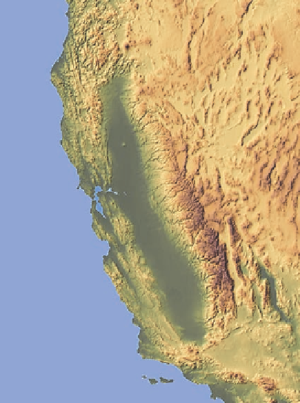
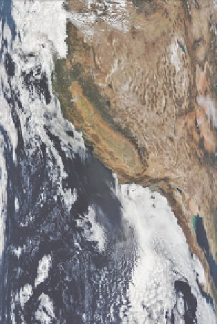
Figure 7.24 Airflow and precipitation patterns in California.
(a) Map showing the major landform regions in California. (b) Geography of
mean annual precipitation. The pattern of precipitation follows the geography of the land, with greater rainfall on the windward sides of the
mountain ranges and less rainfall on the leeward sides. (c) You can see these patterns on the satellite image, with green areas representing
relatively dense vegetation where high rainfall occurs, and brown zones reflecting less vegetation in areas of relatively low precipitation.