Geoscience Reference
In-Depth Information
Cirrostratus: thin, gauze-like sheets; usually gray
and featureless but produce spectacular colors at
sunsets; usually a sign of approaching rain
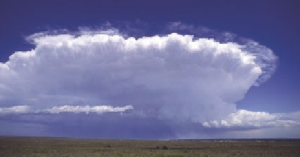
Cumulonimbus: thunderheads, extending to the
tropopause or beyond, with typical anvil-shaped top;
most storm clouds are cumulonimbus
Tropopause
Cirrostratus
High level
above 6 km
(above 20,000 feet)
Stratus: thick, dull gray, low-lying layers; occurs as
fog at ground level, often produces mist or drizzle
Middle level
2-6 km
(6,500 to 20,000 ft)
Nimbostratus: dark rain clouds; form near the ground
but usually extend upward
Cumulonimbus
Low level
below 2 km
(0 to 6,500 ft)
Nimbostratus
Stratocumulus: forms in patches, sheets, or layers of
white or gray; can produce overcast winter skies but
clears quickly in summer
Figure 7.18 Cloud classification.
Clouds are classified according to their height and
form. Most of these categories are variations on the three basic forms of clouds: cirrus,
stratus, and cumulus.