Geoscience Reference
In-Depth Information
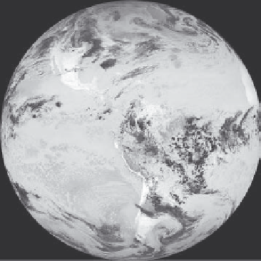
VISUAL CONCEPT CHECK
6.3
Which one of the following answers correctly describes the
location of the ITCZ in this June 2004 GOES east infrared
satellite image? White areas represent clouds.
a)
The ITCZ is the zone of high pressure seen in the center of
the Atlantic Ocean east of Florida.
b)
The ITCZ is the band of clouds in the United States that
extends from Texas into the Great Lakes region.
c)
The ITCZ is the band of clouds that extends east and west
through the northern part of South America.
d)
The ITCZ is the large zone of clear skies in the southern
part of South America.
Midlatitude Circulation
Now let's examine the way the atmosphere circulates in the mid-
latitudes. In general, the primary purpose of midlatitude circula-
tion is to mix the cool polar air that originates at high latitudes
and the warm tropical air that develops at lower latitudes. With
this mixing in mind, the midlatitudes are the regions where these
contrasting air masses converge. The following discussion de-
scribes the circulatory processes in the midlatitudes and how they
function in the context of balancing temperature differences.
The focal point of midlatitude circulation is the
polar
front
, which on average occurs at about 60° N and S latitudes
(Figure 6.19). This atmospheric feature is the contact between
cold air orginating at very high latitudes and the relatively warm
air that streams northward from the tropics. You can see how
tropical air is pumped into the midlatitudes by looking again
at Figure 6.16. For the purposes of this discussion, focus your
attention on the Northern Hemisphere and notice that the mid-
latitudes are north of the STH. Remember that this pressure
system is centered at about 30° N and consists of warm, dry air
that spirals downward in a clockwise fashion. As this descend-
ing air reaches the surface, it diverges, with air on the south-
ern side of the system flowing toward the ITCZ in the form
of northeasterly winds. In contrast, air on the north side of the
STH flows northward in association with Ferrel Cells that are
located between the STH and Polar front. These winds tend to
be southwesterly. It is this southwesterly air that flows toward
the polar front, where it converges with air flowing southward
from the highest latitudes. This southwesterly flow of air con-
tributes to the westerly winds, or
westerlies
, that prevail in the
midlatitudes.
The midlatitude westerlies are especially important because
they often flow at very high speeds, reaching velocities of be-
tween 350 km/h and 450 km/h (about 200 mi/h and 250 mi/h)
in the upper troposphere. The winds reach these extreme speeds
due to a distinct temperature gradient along the polar front, which
(a)
(b)
Figure 6.18 Global vegetation and the Subtropical High (STH)
Pressure System.
(a) Brown shades represent sparse vegeta-
tion in deserts, whereas progressively darker shades of green
represent progressively denser vegetation such as the Amazon
rainforest. The extensive deserts in northern Africa and the
Arabian Peninsula exist because these regions are dominated by
the STH. (b) The Rub al-Khali, or Empty Quarter, of the Arabian
Peninsula is a large sea of sand, as large as all of France, with no
roads and hardly any rainfall.
Polar front
The contact in the midlatitudes between warm
tropical air and colder polar air.
Midlatitude winds that generally flow from west
Westerlies
to east.