Geoscience Reference
In-Depth Information
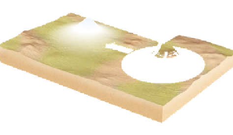
Side view
Clouds
Clear
skies
Cyclone
Anticyclone
Oblique view
Cool air descends
into anticyclone
and warms
Low pressure
Warm air ascends
into cyclone
and cools
High pressure
Advection
(Horizontal air flow)
Air flows counterclockwise
around cyclone in
Northern Hemisphere
Air flows clockwise
around anticyclone in
Northern Hemisphere
Surface air flows
toward regions
of low pressure
Low pressure
(air converges and moves up)
High pressure
(air moves down and diverges)
(a)
(b)
Figure 6.5 Atmospheric pressure systems.
Oblique view (a) and side view (b) of typical low- and high-pressure systems. In a low-
pressure system, air converging at the surface rises and forms clouds. In a high-pressure system, air descends and diverges at the surface;
these systems are usually associated with clear skies.
that the air is moving counterclockwise around this low. Another
low exists in the western part of the North Atlantic, over eastern
Canada, where the winds are also circulating counterclockwise. In
the central Atlantic, between the two lows, a broad area of high
pressure exists that is rotating clockwise. On the western side
of this system the air is flowing southwest to northeast, whereas
on the eastern side of the system the air is moving northwest to
southeast. Another way to describe these patterns is to state that the
winds on the western side of the high are southwesterly and that
they are northwesterly on the system's eastern side. Many people
mistakenly believe that the named direction of wind reflects the
direction in which the air is moving. Instead, the name of the wind
direction, such as “westerlies,” reflects the direction from which the
air is coming (Figure 6.7). Westerly winds, for example, originate
in the west and flow toward the east. Similarly, a north wind in the
Northern Hemisphere brings in air from the north toward the south.
Although atmospheric pressure maps such as Figure 6.6 are
useful to illustrate detailed information, you can also observe
basic barometric patterns by viewing satellite images such as the
view of western Europe in Figure 6.8. Notice that France, Spain,
and Germany are cloud-free, whereas Great Britain and Ireland
are shrouded in a swirling band of clouds. Zones of clear sky,
Northerlies
L
1008
N
L
Westerlies
Easterlies
H
Southerlies
Figure 6.7 Compass headings and wind directions.
Winds are named for the direction from which they originate.
Westerly winds, for example, originate in the west and flow
toward the east.
Figure 6.6 Atmospheric pressure map of the North Atlantic.
The red arrows represent the direction of the winds. Notice the
pressure variability across the ocean and the way air flows.