Geoscience Reference
In-Depth Information
Another technical constraint is related to the rate at
which the data are published online and can cause a delay in
their processing and display by the application. For instance,
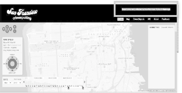
the map “Crimespotting” (Table 4.1, map no. 2) depends on
the rate at which the data are made available by the San
Francisco police reports on criminal activity. As updates are
not added daily, after a few days without any new data, the
map remains empty as seen on the print screen in
Figure 4.7. The time of the last update is indicated at the
top-right of the page to account for the state of the map.
Mapping applications rely on the changes made to their
base maps but also to their data sources. A change in the
one,
the
other
or
both
may
result
in
a
dysfunctional
application.
Figure 4.7.
“San Francisco Crimespotting”, Stamen Design, shows that the
police's last update was published five days before
Moreover, the maps are often made operational at the cost
of some technical bricolage. The London underground map
(Table 4.1, map no. 17, Figure 4.3) illustrates this notion.
Matthew
Somerville
explains
his
application
on
the
right-side
(
What
is
this?
)
and
highlights
the
possible
technical errors:
Search WWH ::

Custom Search