Geoscience Reference
In-Depth Information
- it is necessary to know the cognitive and psycho-physical
parameters that determine the abilities of the user to
understand, learn and remember the information conveyed
by the map [CRA 01, p.237].
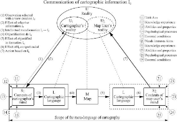
Anton Koláčný's model from 1969 (see Figure 2.1)
illustrates this overlap between information and
communication theory and cartography. Shannon's model is
easily recognized, but Koláčný makes it more complex at
several levels of the communication process. The encoding
capacities of the cartographers, but also the decoding
abilities of the recipient are influenced by the “aim” (11), the
“knowledge experience” (12), the “abilities” (13), the
“psychological processes” (14) or the “external conditions”
(15). The reader's feedback on the map is displayed (7);
however, it does not refer to the map itself but to the reality
illustrated by the map (“
U-Reality
”), on which the reader can
act.
Figure 2.1.
Model made on the basis of Montello [MON 02, p.292], based
on Koláčný's article [KOL 69]
Search WWH ::

Custom Search