Geoscience Reference
In-Depth Information
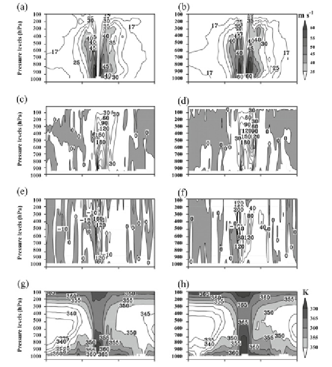
Fig. 3:
East-west cross-sections of case 2 (Nargis) at peak intensity through centre
latitude of cyclone: (a) CNTL, (b) 3DVAR for horizontal wind (m s
-1
), (c-d) same as
(a-b) but for vorticity (10
-5
s
-1
), (e-f) same as (a-b) but for vertical velocity (cm s
-1
) and
(g-h) also same as (a-b) but for equivalent potential temperature (K).
SSM/I winds improved the spatial distribution of rainfall. In quantitative
prediction of rainfall, the 3DVAR performs better up to about 9 cm of rainfall
as ETS is greater than 0.2.
3.3 Impact of DWR Data on TC Forecast
The impact of improved initial conditions with the DWR observations on
prediction of TCs over the BoB is given in this section. Four recent severe
cyclones that occurred between 2007 and 2010: 'Sidr', 'Aila', 'Laila' and 'Jal'
over the BoB are chosen for the study. Evolution of each of these cyclones,
starting from different initial conditions (00 and 12 UTC of each day), are
Search WWH ::

Custom Search