Geoscience Reference
In-Depth Information
June 2007. The satellite imagery showed open eye at 06 UTC of 4 June 2007.
It intensified into a super cyclonic storm (T6.5) at 15 UTC of 4 June. Thereafter,
it moved in a west-northwesterly direction and started weakening gradually
due to relatively colder sea surface temperature and increasing vertical wind
shear. It crossed Oman coast as a very severe cyclonic storm around 03 UTC
of 6 June. After crossing Oman coast, it emerged into the Gulf of Oman,
weakened gradually and moved in a north-northwesterly direction. It made
second landfall over Iran coast near longitude 58.5 °E between 03 and 04 UTC
of 7 June 2007 as a cyclonic storm. The system caused loss of life and property
in Oman and Iran due to heavy rainfall, strong winds and storm surge.
4. Results and Discussion
The results as obtained from the above mentioned two cyclone cases are
described in this section.
4.1 Improvement in Track Simulation
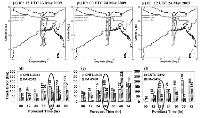
Figure 2(a-c) represents the tracks of the cyclone Aila with different initial
conditions from both control (CNTL) and data assimilation (DA) experiments.
It is noticed that the track of the cyclone has been improved in DA experiments
for each cases and more closer to the best-fit track position as estimated through
IMD. We have also evaluated the vector displacement error (VDE) in both
CNTL and DA experiments with respect to the best track observation of IMD.
Figure 2(d-f) represents the error associated with the initial condition of 12
UTC 23 May 2009, 00 UTC 24 May 2009 and 12 UTC 24 May 2009,
Fig. 2:
Track and vector displacement errors (km) of cyclone Aila with CNTL and DA
experiments from different initial conditions: (a, d) valid at 12 UTC 23 May 2009, (b, e)
valid at 00 UTC 24 May 2009 and (c, f) valid at 12 UTC 24 May 2009.
Search WWH ::

Custom Search