Geoscience Reference
In-Depth Information
observations on hourly basis which are utilized in cyclone monitoring and
forecasting. High Wind Speed Recorder (HWSR) has also been installed and
are operational at 13 coastal stations. The upper air meteorological data collected
all over the country are used on real time basis for operational forecasting.
The average confidence level of locating the centre of the system over the
NIO is about 55 km (Goyal et al., 2013).
4.1.1 Radar Observations
IMD has a network of seven Doppler Weather Radars/Cyclone Detection Radars
along the east and the west coast (Fig. 4), which have about 400 km effective
range and is most useful in fixing the centre of the cyclone, when the system
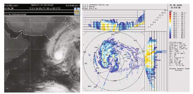
comes under their surveillance. A typical TC imagery by DWR is shown in
Fig. 3.
Doppler weather radars provide vital information on radial velocity and
spectral width in addition to reflectivity (Raghavan, 2013). Reflectivity
estimates obtained from these radars are more accurate in comparison to those
from conventional radars as the Doppler weather radars have capability for
correcting the values for clutters, bright band etc. Surface Rainfall Intensity
(second level product derived from reflectivity) and other hydrological products
like Precipitation Accumulation (PAC) and Vertical Integrated Liquid (VIL)
are very important for issuing warnings for heavy rain, flash flood and hail.
4.1.2 Satellite Observations
At present IMD is receiving and processing meteorological data from two Indian
satellites namely Kalpana-1 and INSAT-3A. Kalpana-1 was launched on 12
th
September, 2002 and is located at 74° E. INSAT-3A was launched on 10 April,
2003 and is located at 93.5° E. Kalpana-1 and INSAT-3A both have pay load
of Very High Resolution Radiometer (VHRR) for imaging the earth in three
channels, Visible (0.55-0.75 m), Infra-red (10.5-12.5 m) and Water vapour
Fig. 3:
Typical INSAT imagery of cyclone, Phyan and Doppler Weather Radar
imagery of cyclone, Aila.


Search WWH ::

Custom Search