Geoscience Reference
In-Depth Information
depression east-southeast of Chennai, India. The Joint Typhoon Warning Centre
issued a tropical cyclone warning on the tropical cyclone early on November 14.
By mid morning the IMD advised the eastern coast of India that the system
was expected to cross Andhra Pradesh by noon the next day (local time). Later
that morning the deep depression intensified into a cyclonic storm and was
named Khai-Muk and the cyclone watch was raised to a warning for Andhra
Pradesh coast with Khai-Muk forecast to intensify even further before it made
landfall in the afternoon or evening of November 15 between Bapatla and
Kakinada near Machilipatnam. However, the system became sheared to the
western periphery and the IMD downgraded it back into a deep depression.
Khai-Muk headed northwest and then northwards after making landfall in
Andhra Pradesh.
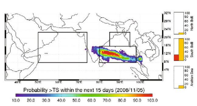
CFAN genesis potential predictions on 5
th
November indicated the very
high probability of cyclone genesis (Fig. 5) over South Central BoB, which
extended to south coastal Andhra. Cyclone Khai-Muk genesis was predicted
by CFAN model with lead-time of eight days in advance. Track ensemble
predictions (Fig. 6) for Khai-Muk on 5
th
November, indicates that system would
move WNW direction and would landfall over south coastal Andhra region.
CFAN model predicted the probable movement of cyclonic storm with lead-
time of ten days with about 90% accuracy of landfall
.
4. Summary and Conclusions
Extended range predictions from CFAN, based on multiple ensembles from
specialized high quality global models, as well as different other models, appear
to have reliable skills for cyclogenesis and track density prediction. The
Fig. 5:
Cyclone genesis potential prediction by CFAN on 5
th
Nov 2008, the eminent
probability of cyclone genesis over South Central BoB, which extended to south coastal
Andhra. Model predicted the Cyclone Khai-Muk with lead-time of eight days in advance.
Search WWH ::

Custom Search